IMAGES TAKEN NEAR TO
Warwick Bailey Close, COLCHESTER, CO4 5ER
Introduction
This page details the photographs taken nearby to Warwick Bailey Close, CO4 5ER by members of the Geograph project.
The Geograph project started in 2005 with the aim of publishing, organising and preserving representative images for every square kilometre of Great Britain, Ireland and the Isle of Man.

There are currently over 7.5m images from over14,400 individuals and you can help contribute to the project by visiting https://www.geograph.org.uk
Image Map
Images are licensed for reuse under creativecommons.org/licenses/by-sa/2.0
Notes
- Clicking on the map will re-center to the selected point.
- The higher the marker number, the further away the image location is from the centre of the postcode.
Image Listing (9 Images Found)
Images are licensed for reuse under creativecommons.org/licenses/by-sa/2.0
Image
Details
Distance
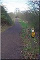
2
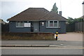
The Dental Studio on Braiswick, Colchester
Image: © David Howard
Taken: 27 May 2024
0.07 miles
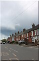
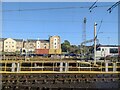
3
Axial Drive Braiswick
A newish development to the north of Colchester convenient for North Station.
Image: © Glyn Baker
Taken: 7 Mar 2019
0.15 miles
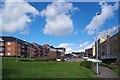
7
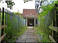
Pedestrian subway under railway, Colchester
A lengthy passage beneath three running tracks and a further nine sidings. There are two narrow breaks in the bridge, one of which has steps ascending to track level, but gated off and apparently disused.
Image: © Robin Webster
Taken: 2 Jul 2016
0.21 miles
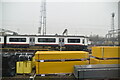
8
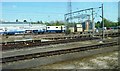
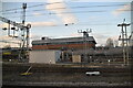
Railway lines and depot at Colchester
Viewed from train approaching Colchester Station.
Image: © Clint Mann
Taken: 4 May 2016
0.23 miles