IMAGES TAKEN NEAR TO
Mile End Road, COLCHESTER, CO4 5EA
Introduction
This page details the photographs taken nearby to Mile End Road, CO4 5EA by members of the Geograph project.
The Geograph project started in 2005 with the aim of publishing, organising and preserving representative images for every square kilometre of Great Britain, Ireland and the Isle of Man.

There are currently over 7.5m images from over14,400 individuals and you can help contribute to the project by visiting https://www.geograph.org.uk
Image Map
Images are licensed for reuse under creativecommons.org/licenses/by-sa/2.0
Notes
- Clicking on the map will re-center to the selected point.
- The higher the marker number, the further away the image location is from the centre of the postcode.
Image Listing (21 Images Found)
Images are licensed for reuse under creativecommons.org/licenses/by-sa/2.0
Image
Details
Distance
1
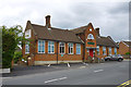
The Lorraine George School of Dancing, Colchester
Agricultural House, 305 Mile End Road, was formerly offices. The painted panel on the end wall is just about indecipherable, although the bottom line may have yielded something if I had crossed the road to have a closer look.
Image: © Robin Webster
Taken: 2 Jul 2016
0.01 miles
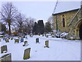
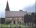
4
St. Michael; the parish church of Mile End
This church was built in 1854 and designed by Hakewill.
If you look at this church as marked on the O/S map you will find the line of two grid squares cuts through the centre of the church, north to south. As the picture only shows the west front of the church I have decided it is correct to be placed in one square.
Image: © Robert Edwards
Taken: 5 May 2008
0.04 miles
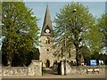
5

St Michael's Church, Mile End, Colchester, Essex
Image: © Peter Stack
Taken: 13 Aug 2009
0.06 miles
6
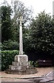
War Memorial, Mile End
Commemorates those of the Parish of Myland who fell in the two World Wars.
Image: © John Myers
Taken: 1 Oct 2006
0.07 miles
8
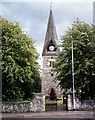
St. Michael's, Myland
Myland Parish church - spire.
Image: © John Myers
Taken: 1 Oct 2006
0.10 miles
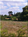
9
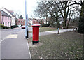
Dickenson Road looking west, Colchester
Looking past the postbox towards the cycle path by Shepherd Drive.
Image: © MJ Reilly
Taken: 11 Mar 2010
0.12 miles
10
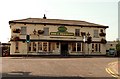
'Dog & Pheasant' public house, Mile End, Essex
This pub stands alongside part of the original A.134 road, but this section has now been bypassed by a new road.
Image: © Robert Edwards
Taken: 11 Sep 2006
0.13 miles