IMAGES TAKEN NEAR TO
Sebastian Close, COLCHESTER, CO4 3SH
Introduction
This page details the photographs taken nearby to Sebastian Close, CO4 3SH by members of the Geograph project.
The Geograph project started in 2005 with the aim of publishing, organising and preserving representative images for every square kilometre of Great Britain, Ireland and the Isle of Man.

There are currently over 7.5m images from over14,400 individuals and you can help contribute to the project by visiting https://www.geograph.org.uk
Image Map
Images are licensed for reuse under creativecommons.org/licenses/by-sa/2.0
Notes
- Clicking on the map will re-center to the selected point.
- The higher the marker number, the further away the image location is from the centre of the postcode.
Image Listing (2 Images Found)
Images are licensed for reuse under creativecommons.org/licenses/by-sa/2.0
Image
Details
Distance
1
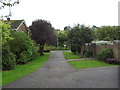
Greenstead
Footpath from Isbourne Road to Salary Brook valley.
Image: © Burgess Von Thunen
Taken: 18 Oct 2012
0.23 miles
2

Sherebourne Rd and Salary Brook LNR
An open area in Image https://www.colchester.gov.uk/info/cbc-article/?catid=country-parks-and-local-nature-reserves&id=KA-01610
Image: © Glyn Baker
Taken: 29 Mar 2019
0.24 miles