IMAGES TAKEN NEAR TO
Hawthorn Avenue, COLCHESTER, CO4 3JR
Introduction
This page details the photographs taken nearby to Hawthorn Avenue, CO4 3JR by members of the Geograph project.
The Geograph project started in 2005 with the aim of publishing, organising and preserving representative images for every square kilometre of Great Britain, Ireland and the Isle of Man.

There are currently over 7.5m images from over14,400 individuals and you can help contribute to the project by visiting https://www.geograph.org.uk
Image Map
Images are licensed for reuse under creativecommons.org/licenses/by-sa/2.0
Notes
- Clicking on the map will re-center to the selected point.
- The higher the marker number, the further away the image location is from the centre of the postcode.
Image Listing (2 Images Found)
Images are licensed for reuse under creativecommons.org/licenses/by-sa/2.0
Image
Details
Distance
1

Sir Charles Lucas Arts College
Comprehensive School named after the leader of the Royalist Army during the siege of Colchester in the English Civil War.
Image: © Angela Tuff
Taken: 24 Jan 2006
0.19 miles
2
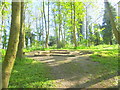
A small wood by Greenstead estate
I never thought that this wood would be as nice as this; given its proximity to Greenstead; thought it would be full of rubbish and crack dens, but not at all. The logs in the middle of the pic are an outdoor classroom that I helped construct when doing work for The Conservation Volunteers.
Image: © Mr James D
Taken: 4 May 2019
0.25 miles