IMAGES TAKEN NEAR TO
St. Andrews Avenue, COLCHESTER, CO4 3HU
Introduction
This page details the photographs taken nearby to St. Andrews Avenue, CO4 3HU by members of the Geograph project.
The Geograph project started in 2005 with the aim of publishing, organising and preserving representative images for every square kilometre of Great Britain, Ireland and the Isle of Man.

There are currently over 7.5m images from over14,400 individuals and you can help contribute to the project by visiting https://www.geograph.org.uk
Image Map
Images are licensed for reuse under creativecommons.org/licenses/by-sa/2.0
Notes
- Clicking on the map will re-center to the selected point.
- The higher the marker number, the further away the image location is from the centre of the postcode.
Image Listing (53 Images Found)
Images are licensed for reuse under creativecommons.org/licenses/by-sa/2.0
Image
Details
Distance
1
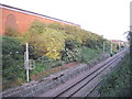
Railway line looking toward Hythe Station, Colchester
Image: © PAUL FARMER
Taken: 26 Jun 2010
0.04 miles
3
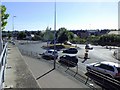
Colchester, Ipswich Rd.
This roundabout is a double one, the second can be seen in the top right of the photo. Although the traffic flow seems flow quite freely it has been decided that it should revert back to a single roundabout as it was years ago.
Image: © Peter Pearson
Taken: 11 Sep 2016
0.06 miles
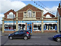
4
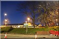
Waitrose on St Andrew's Avenue, Colchester
Image: © David Howard
Taken: 23 Feb 2019
0.06 miles
5
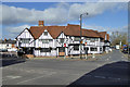
The Rose and Crown Hotel, Colchester
In origin 15th century but many features are not original, so only a grade II listed building.
Image: © Robin Webster
Taken: 9 Feb 2019
0.12 miles
6
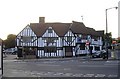
East Gate Inn, Colchester
Established 1733 it claims, but it apparently does not merit national listing.
Image: © Robin Webster
Taken: 9 Feb 2019
0.12 miles
7
The Rose and Crown Hotel, East Street, Colchester
The Rose and Crown Hotel was originally a 14th Century coaching inn, it has been lovingly restored over the years.
Image: © PAUL FARMER
Taken: 26 Jun 2010
0.12 miles
8
Old Bridge Marker by the A133, Cowdray Avenue, Colchester
Bridge Marker by the A133, in parish of Colchester (Colchester District), Cowdray Avenue Railway Bridge, in North parapet.
Surveyed
Milestone Society National ID: EX_COLC05br
Image: © Milestone Society
Taken: Unknown
0.12 miles
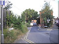
9

Ipswich Road Postbox on Ipswich Road
Postbox No.CO1 26
Image: © Geographer
Taken: 3 Oct 2015
0.12 miles
10
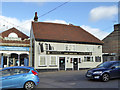
C.C. Discount Heating, Colchester
On East Street, just east of the level crossing - note the safe height under the wires warning bells.
Image: © Robin Webster
Taken: 9 Feb 2019
0.12 miles