IMAGES TAKEN NEAR TO
Bream Court, COLCHESTER, CO4 3EW
Introduction
This page details the photographs taken nearby to Bream Court, CO4 3EW by members of the Geograph project.
The Geograph project started in 2005 with the aim of publishing, organising and preserving representative images for every square kilometre of Great Britain, Ireland and the Isle of Man.

There are currently over 7.5m images from over14,400 individuals and you can help contribute to the project by visiting https://www.geograph.org.uk
Image Map
Images are licensed for reuse under creativecommons.org/licenses/by-sa/2.0
Notes
- Clicking on the map will re-center to the selected point.
- The higher the marker number, the further away the image location is from the centre of the postcode.
Image Listing (20 Images Found)
Images are licensed for reuse under creativecommons.org/licenses/by-sa/2.0
Image
Details
Distance
1
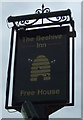
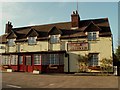
The sign for The Beehive on Bromley Road
Looking west towards the town.
Image: © MJ Reilly
Taken: 11 Mar 2009
0.10 miles

6
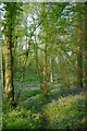
Welsh Wood Path
Welsh Wood http://www.wildessex.net/sites/Welsh%20Wood.htm is a scrap of ancient woodland managed by Colchester Council
Image: © Glyn Baker
Taken: 25 Apr 2011
0.15 miles
7

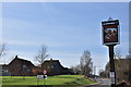
Longridge Park from The Beehive
Looking south across the open land left between the houses.
Image: © MJ Reilly
Taken: 11 Mar 2009
0.15 miles
8
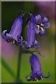
Welsh Wood Bluebell
I don't know why but the true colour of a Bluebell is almost impossible to capture with a camera.
Image: © Glyn Baker
Taken: 25 Apr 2011
0.16 miles