IMAGES TAKEN NEAR TO
Harwich Road, COLCHESTER, CO4 3DL
Introduction
This page details the photographs taken nearby to Harwich Road, CO4 3DL by members of the Geograph project.
The Geograph project started in 2005 with the aim of publishing, organising and preserving representative images for every square kilometre of Great Britain, Ireland and the Isle of Man.

There are currently over 7.5m images from over14,400 individuals and you can help contribute to the project by visiting https://www.geograph.org.uk
Image Map
Images are licensed for reuse under creativecommons.org/licenses/by-sa/2.0
Notes
- Clicking on the map will re-center to the selected point.
- The higher the marker number, the further away the image location is from the centre of the postcode.
Image Listing (12 Images Found)
Images are licensed for reuse under creativecommons.org/licenses/by-sa/2.0
Image
Details
Distance
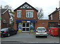
1
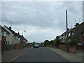
Hazelton Road, Colchester
Looking north west.
Image: © JThomas
Taken: 24 Apr 2017
0.06 miles
3
Harwich Road, Colchester
Looking north east at the junction with Hazelton Road.
Image: © JThomas
Taken: 24 Apr 2017
0.06 miles
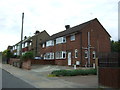
6
Goring Road from Harwich Road
View of "White City", Colchester
Image: © MJ Reilly
Taken: 11 Mar 2009
0.19 miles
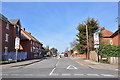
7
Bus stop on Harwich Road, Colchester
Looking east.
Image: © JThomas
Taken: 24 Apr 2017
0.19 miles
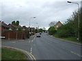
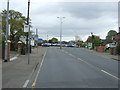
8

Bus shelter in Parson's Heath, Harwich Road
Image: © David Smith
Taken: 31 May 2017
0.22 miles
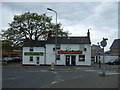
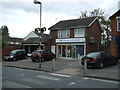
10

Pedestrian crossing by post office, Harwich Road
Image: © David Smith
Taken: 31 May 2017
0.24 miles