IMAGES TAKEN NEAR TO
St. Andrews Avenue, COLCHESTER, CO4 3AL
Introduction
This page details the photographs taken nearby to St. Andrews Avenue, CO4 3AL by members of the Geograph project.
The Geograph project started in 2005 with the aim of publishing, organising and preserving representative images for every square kilometre of Great Britain, Ireland and the Isle of Man.

There are currently over 7.5m images from over14,400 individuals and you can help contribute to the project by visiting https://www.geograph.org.uk
Image Map
Images are licensed for reuse under creativecommons.org/licenses/by-sa/2.0
Notes
- Clicking on the map will re-center to the selected point.
- The higher the marker number, the further away the image location is from the centre of the postcode.
Image Listing (10 Images Found)
Images are licensed for reuse under creativecommons.org/licenses/by-sa/2.0
Image
Details
Distance
1
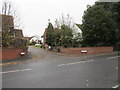
Junction of Tabor Road with Greenstead Road, Hythe, Colchester
Image: © Richard Rogerson
Taken: 20 Nov 2012
0.11 miles
2
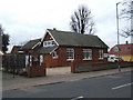
St Johns Ambulance Station
This is the St Johns Ambulance Station and Garage in Greensted Rd Colchester
Image: © Glyn Baker
Taken: 26 Mar 2006
0.12 miles
3
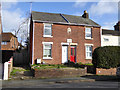
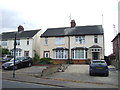
Abstinence Cottages, Greenstead Road, Colchester
Dated 1897(?) on the upper stone on the front. The lower tablet is interesting - see Image
Image: © Robin Webster
Taken: 9 Feb 2019
0.13 miles
4
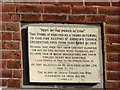
Tablet on Abstinence Cottages
For the cottages, see Image
Image: © Robin Webster
Taken: 9 Feb 2019
0.13 miles

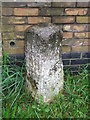
7

Harwich 20
Old milestone on the A.137 at Colchester, Essex. For close up view see http://www.geograph.org.uk/photo/4667531
Image: © Keith Evans
Taken: 16 Sep 2015
0.24 miles
8
Old Milestone
Old milestone on the A.137 at Colxhester, Essex. For overall view see http://www.geograph.org.uk/photo/4667552
Image: © Keith Evans
Taken: 16 Sep 2015
0.24 miles
9

Old Milepost by the A137, Harwich Road, Colchester
Cast iron post by the A137, in parish of COLCHESTER (COLCHESTER District), Harwich Road, 20m North of junction with Crown Lane, by the road. Erected by the Essex Second District turnpike trust in the 19th century.
Inscription reads:-
: Har / 20 : : Col / 1 :
Essex HER.
SMR Number: 15783 https://www.heritagegateway.org.uk/Gateway/Results_Single.aspx?uid=MEX1032865&resourceID=1001
Milestone Society National ID: EX_COHH52.
Image: © JV Nicholls
Taken: 2 May 2006
0.24 miles
10
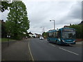
Harwich Road (A137), Colchester
Looking north east.
Image: © JThomas
Taken: 24 Apr 2017
0.25 miles