IMAGES TAKEN NEAR TO
Elmstead Road, COLCHESTER, CO4 3AE
Introduction
This page details the photographs taken nearby to Elmstead Road, CO4 3AE by members of the Geograph project.
The Geograph project started in 2005 with the aim of publishing, organising and preserving representative images for every square kilometre of Great Britain, Ireland and the Isle of Man.

There are currently over 7.5m images from over14,400 individuals and you can help contribute to the project by visiting https://www.geograph.org.uk
Image Map
Images are licensed for reuse under creativecommons.org/licenses/by-sa/2.0
Notes
- Clicking on the map will re-center to the selected point.
- The higher the marker number, the further away the image location is from the centre of the postcode.
Image Listing (15 Images Found)
Images are licensed for reuse under creativecommons.org/licenses/by-sa/2.0
Image
Details
Distance
2
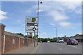
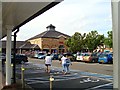
What hit the sign? Colne Causeway, Colchester
Image: © David Smith
Taken: 31 May 2017
0.06 miles
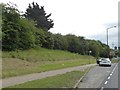
5

Salary Brook
Looking upstream from the bridge on Elmstead Rd, towards Greensted. I wouldn't fancy the premiums on the flood insurance of the new houses on the bank.
Image: © Glyn Baker
Taken: 3 Apr 2010
0.10 miles
6
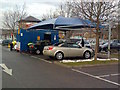
Car Wash, Tesco's Car Park, Colchester
Image: © Alex McGregor
Taken: 7 Dec 2010
0.13 miles
7
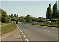
The A133, heading away from Colchester
The tower blocks in the distance belong to the University of Essex.
Image: © Robert Edwards
Taken: 12 May 2008
0.14 miles
10
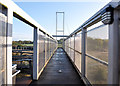
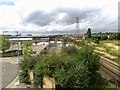
Footbridge to the University of Essex
Footbridge over the railway at the Hythe, Colchester
Image: © MJ Reilly
Taken: 22 Oct 2009
0.19 miles