IMAGES TAKEN NEAR TO
Mayfield Close, COLCHESTER, CO4 0QL
Introduction
This page details the photographs taken nearby to Mayfield Close, CO4 0QL by members of the Geograph project.
The Geograph project started in 2005 with the aim of publishing, organising and preserving representative images for every square kilometre of Great Britain, Ireland and the Isle of Man.

There are currently over 7.5m images from over14,400 individuals and you can help contribute to the project by visiting https://www.geograph.org.uk
Image Map
Images are licensed for reuse under creativecommons.org/licenses/by-sa/2.0
Notes
- Clicking on the map will re-center to the selected point.
- The higher the marker number, the further away the image location is from the centre of the postcode.
Image Listing (18 Images Found)
Images are licensed for reuse under creativecommons.org/licenses/by-sa/2.0
Image
Details
Distance
1
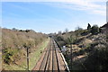
Looking east down the mainline
The mainline looking towards Manningtree
Image: © MJ Reilly
Taken: 11 Mar 2009
0.08 miles
2
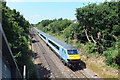
Norwich bound
A Greater Anglian train leaves Colchester on route to Norwich
Image: © Peter Pearson
Taken: 18 Jul 2013
0.10 miles
3
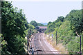
Ipswich Rd bridge
The road bridge carrying the A1232 (formerly the A12, before the construction of the Colchester Northern Bypass) over the Norwich to London,Liverpool St rail track
Image: © Peter Pearson
Taken: 18 Jul 2013
0.11 miles
4
Mayor's Spinney, Highwoods Country Park
Image: © PAUL FARMER
Taken: 10 Jul 2010
0.12 miles
5

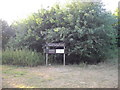
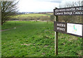
Old Bridge Marker by the A1232, Ipswich Road, Colchester parish
Bridge Marker by the A1232, in parish of Colchester (Colchester District), Ipswich Road Railway Bridge, in West parapet.
Surveyed
Milestone Society National ID: EX_COLC06br
Image: © Milestone Society
Taken: Unknown
0.13 miles
6
Unofficial Path
This path leads out of High Woods Country Park north of Colchester. However it is of little use to the average walker as you are confronted with the back garden gates of Friars Close (behind the photographer) and no way to reach a public road or right of way.
Image: © Glyn Baker
Taken: 29 May 2006
0.13 miles
7
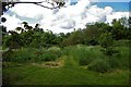
Mayor's Spinney
This was taken close to the entrance from the Ipswich Road.
Mayor's Spinney is the name given to this area of High Woods Country Park.
The Country Park covers over 300 acres, see the link.
http://www.visitcolchester.com/thedms.asp?dms=13&venue=0654060
Image: © terry joyce
Taken: 19 Mar 2008
0.13 miles
8
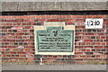
Ipswich Road Rail Bridge plaque
Plaque to commemorate the widening of the bridge in 1931.
Image: © MJ Reilly
Taken: 11 Mar 2009
0.13 miles
10
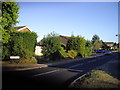
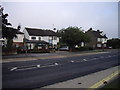
Cloverlands, St Johns Estate Colchester
Image: © PAUL FARMER
Taken: 10 Jul 2010
0.15 miles