IMAGES TAKEN NEAR TO
Green Lane, COLCHESTER, CO4 0JA
Introduction
This page details the photographs taken nearby to Green Lane, CO4 0JA by members of the Geograph project.
The Geograph project started in 2005 with the aim of publishing, organising and preserving representative images for every square kilometre of Great Britain, Ireland and the Isle of Man.

There are currently over 7.5m images from over14,400 individuals and you can help contribute to the project by visiting https://www.geograph.org.uk
Image Map
Images are licensed for reuse under creativecommons.org/licenses/by-sa/2.0
Notes
- Clicking on the map will re-center to the selected point.
- The higher the marker number, the further away the image location is from the centre of the postcode.
Image Listing (6 Images Found)
Images are licensed for reuse under creativecommons.org/licenses/by-sa/2.0
Image
Details
Distance
1
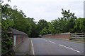
A137 bridge over railway at Welshwood Park
Image: © David Smith
Taken: 31 May 2017
0.14 miles
2
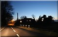
Harwich Road, Fox Street
This is the last bit of countryside before entering Colchester.
Image: © David Howard
Taken: 23 Feb 2019
0.14 miles
3
Alleyway from St Jude Close leading to St Johns Road, Colchester
Image: © PAUL FARMER
Taken: 21 Jun 2010
0.17 miles
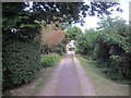
5
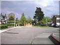
St. Jude Gardens Colchester
This is the entrance to St Jude Gardens on the St John's Estate
Image: © PAUL FARMER
Taken: 1 May 2010
0.21 miles
6
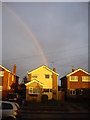
Rainbow behind house in St Jude Close Colchester
Image: © PAUL FARMER
Taken: 12 Dec 2009
0.23 miles