IMAGES TAKEN NEAR TO
Ipswich Road, COLCHESTER, CO4 0HW
Introduction
This page details the photographs taken nearby to Ipswich Road, CO4 0HW by members of the Geograph project.
The Geograph project started in 2005 with the aim of publishing, organising and preserving representative images for every square kilometre of Great Britain, Ireland and the Isle of Man.

There are currently over 7.5m images from over14,400 individuals and you can help contribute to the project by visiting https://www.geograph.org.uk
Image Map
Images are licensed for reuse under creativecommons.org/licenses/by-sa/2.0
Notes
- Clicking on the map will re-center to the selected point.
- The higher the marker number, the further away the image location is from the centre of the postcode.
Image Listing (17 Images Found)
Images are licensed for reuse under creativecommons.org/licenses/by-sa/2.0
Image
Details
Distance
2
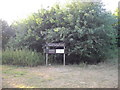
Unofficial Path
This path leads out of High Woods Country Park north of Colchester. However it is of little use to the average walker as you are confronted with the back garden gates of Friars Close (behind the photographer) and no way to reach a public road or right of way.
Image: © Glyn Baker
Taken: 29 May 2006
0.10 miles
3
Friars Grove Primary School, Upland Drive, Colchester
Image: © PAUL FARMER
Taken: 2 Oct 2010
0.13 miles
4

Bluebells and stream, Friars Grove, Colchester
Image: © Mr James D
Taken: 23 Apr 2016
0.14 miles
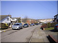
5
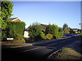
Cloverlands, St Johns Estate Colchester
Image: © PAUL FARMER
Taken: 10 Jul 2010
0.15 miles
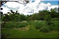
6
Mayor's Spinney, Highwoods Country Park
Image: © PAUL FARMER
Taken: 10 Jul 2010
0.20 miles
7

7- Spot ladybird Coccinella 7-punctata
This photograph follows image number 3431396 the pupal case being that depicted in that photograph. Here the adult beetle has emerged showing the wing cases as an orange colour not the deeper red that comes sometime after emergence.
Image: © Peter Pearson
Taken: 1 Jul 2012
0.20 miles
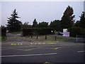
8
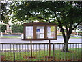
St. John's Community Notice board, Colchester
Image: © PAUL FARMER
Taken: 2 Oct 2010
0.21 miles
9
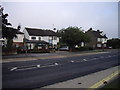
St Dominic Way Colchester
This picture is taken looking toward the shops in St Christopher Parade
Image: © PAUL FARMER
Taken: 17 Feb 2010
0.21 miles
10
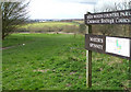
Mayor's Spinney
This was taken close to the entrance from the Ipswich Road.
Mayor's Spinney is the name given to this area of High Woods Country Park.
The Country Park covers over 300 acres, see the link.
http://www.visitcolchester.com/thedms.asp?dms=13&venue=0654060
Image: © terry joyce
Taken: 19 Mar 2008
0.22 miles