IMAGES TAKEN NEAR TO
Broadlands Way, COLCHESTER, CO4 0AL
Introduction
This page details the photographs taken nearby to Broadlands Way, CO4 0AL by members of the Geograph project.
The Geograph project started in 2005 with the aim of publishing, organising and preserving representative images for every square kilometre of Great Britain, Ireland and the Isle of Man.

There are currently over 7.5m images from over14,400 individuals and you can help contribute to the project by visiting https://www.geograph.org.uk
Image Map
Images are licensed for reuse under creativecommons.org/licenses/by-sa/2.0
Notes
- Clicking on the map will re-center to the selected point.
- The higher the marker number, the further away the image location is from the centre of the postcode.
Image Listing (24 Images Found)
Images are licensed for reuse under creativecommons.org/licenses/by-sa/2.0
Image
Details
Distance
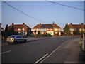
1
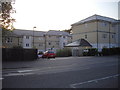
King Cole Road, Colchester
The road is named after the pub that used to stand on this site-The King Cole
Image: © PAUL FARMER
Taken: 26 Jun 2010
0.05 miles
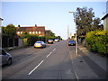
2
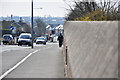
Ipswich Road, looking south
The view heading into town from the rail bridge.
Image: © MJ Reilly
Taken: 11 Mar 2009
0.05 miles
4
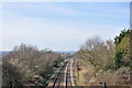
Looking west down the mainline
The view from the Ipswich Road bridge towards Colchester station
Image: © MJ Reilly
Taken: 11 Mar 2009
0.12 miles
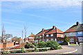
5
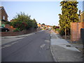
Houses in Goring Road, Colchester
These houses are on the junction of Goring Road and Wilson Marriage Road
Image: © PAUL FARMER
Taken: 26 Jun 2010
0.13 miles
6
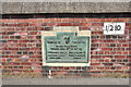
Ipswich Road Rail Bridge plaque
Plaque to commemorate the widening of the bridge in 1931.
Image: © MJ Reilly
Taken: 11 Mar 2009
0.13 miles
7
Goring Road, Wilson Marriage Road junction
A view of "White City", Colchester
Image: © MJ Reilly
Taken: 11 Mar 2009
0.14 miles
8

Old Bridge Marker by the A1232, Ipswich Road, Colchester parish
Bridge Marker by the A1232, in parish of Colchester (Colchester District), Ipswich Road Railway Bridge, in West parapet.
Surveyed
Milestone Society National ID: EX_COLC06br
Image: © Milestone Society
Taken: Unknown
0.14 miles
10
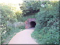
Railway bridge over footpath in Highwoods Country Park
Image: © PAUL FARMER
Taken: 10 Jul 2010
0.15 miles