IMAGES TAKEN NEAR TO
Newbridge Hill, COLCHESTER, CO3 9TB
Introduction
This page details the photographs taken nearby to Newbridge Hill, CO3 9TB by members of the Geograph project.
The Geograph project started in 2005 with the aim of publishing, organising and preserving representative images for every square kilometre of Great Britain, Ireland and the Isle of Man.

There are currently over 7.5m images from over14,400 individuals and you can help contribute to the project by visiting https://www.geograph.org.uk
Image Map
Images are licensed for reuse under creativecommons.org/licenses/by-sa/2.0
Notes
- Clicking on the map will re-center to the selected point.
- The higher the marker number, the further away the image location is from the centre of the postcode.
Image Listing (4 Images Found)
Images are licensed for reuse under creativecommons.org/licenses/by-sa/2.0
Image
Details
Distance
1
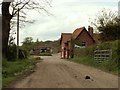
The approach to Newbridge Mill
This farm road is also part of a public footpath.
Image: © Robert Edwards
Taken: 2 May 2008
0.04 miles
2
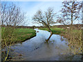
River Colne upstream of New Bridge
For a similar view when rather less full, see Image
Image: © Robin Webster
Taken: 13 Jan 2016
0.05 miles
3
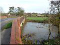
River Colne at New Bridge
The flow is from left to right, with the level a good deal higher than usual.
Image: © Robin Webster
Taken: 13 Jan 2016
0.06 miles
4
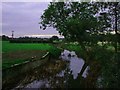
River Colne from "Newbridge"
This is the River Colne looking upstream towards Newbridge Mill. The picture was taken from the “New Bridge”.
Image: © Glyn Baker
Taken: 22 Oct 2005
0.08 miles