IMAGES TAKEN NEAR TO
Porter Drive, COLCHESTER, CO3 9FQ
Introduction
This page details the photographs taken nearby to Porter Drive, CO3 9FQ by members of the Geograph project.
The Geograph project started in 2005 with the aim of publishing, organising and preserving representative images for every square kilometre of Great Britain, Ireland and the Isle of Man.

There are currently over 7.5m images from over14,400 individuals and you can help contribute to the project by visiting https://www.geograph.org.uk
Image Map
Images are licensed for reuse under creativecommons.org/licenses/by-sa/2.0
Notes
- Clicking on the map will re-center to the selected point.
- The higher the marker number, the further away the image location is from the centre of the postcode.
Image Listing (5 Images Found)
Images are licensed for reuse under creativecommons.org/licenses/by-sa/2.0
Image
Details
Distance
1
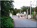
Crossing at Chitts Hill
If it is possible for a human being to be a geograph then this is an example! Here we have the level crossing gatekeeper on the Chitts Hill level crossing doing his duty. This is no sleepy branch line it is the main line between London Liverpool St and Norwich. There can’t be much rest as all the trains for Clacton as well as many freight trains for Harwich and Felixstowe docks pass this way as well. I assume this is one of the last crossings of its kind.
Image: © Glyn Baker
Taken: 22 Oct 2005
0.13 miles
2
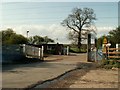
The level crossing at Chitts Hills
The road passing through is called Chitts Hill.
Image: © Robert Edwards
Taken: 2 May 2008
0.15 miles
3
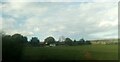
Houses on Chits Hill from the railway
Image: © Christopher Hilton
Taken: 18 Nov 2022
0.21 miles
4
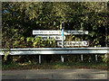
Signpost on Halstead Road
At the junction with Stan way
Image: © Geographer
Taken: 5 Oct 2019
0.23 miles
5
Stan Way, Beacon End, Stanway
At the junction with Halstead Road
Image: © Geographer
Taken: 5 Oct 2019
0.23 miles