IMAGES TAKEN NEAR TO
Turkey Cock Lane, COLCHESTER, CO3 8NB
Introduction
This page details the photographs taken nearby to Turkey Cock Lane, CO3 8NB by members of the Geograph project.
The Geograph project started in 2005 with the aim of publishing, organising and preserving representative images for every square kilometre of Great Britain, Ireland and the Isle of Man.

There are currently over 7.5m images from over14,400 individuals and you can help contribute to the project by visiting https://www.geograph.org.uk
Image Map
Images are licensed for reuse under creativecommons.org/licenses/by-sa/2.0
Notes
- Clicking on the map will re-center to the selected point.
- The higher the marker number, the further away the image location is from the centre of the postcode.
Image Listing (12 Images Found)
Images are licensed for reuse under creativecommons.org/licenses/by-sa/2.0
Image
Details
Distance
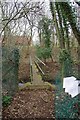
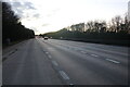
1

Not Worth The Risk
Unlike the Image on Colchester's northern by pass here there is no gap in the safety barrier for pedestrians to use. If one did manage to get across the dual carriageway the Railway level crossing has been closed since October 2018.
Image: © Glyn Baker
Taken: 15 Mar 2019
0.08 miles
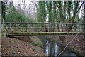
3
Footbridge Over Roman River
The litter on the right is from Railtrack and Essex County Council saying there is a "temporary" closure of the level crossing on the other side of the A12 due to unsafe steps. The works to repair them should have been concluded by early December 2018 see Image my distrust in officialdom made the Image Image I was proved right when I eventually got to Kemp's farm and found the crossing still closed. However there is an alternative route via the Image
Image: © Glyn Baker
Taken: 15 Mar 2019
0.11 miles
4
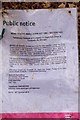
Lies Damn Lies and Public Notices
It is now five months from the issue of this "temporary footpath closure notice", due to last until about 7th December 2018. The footpath is still closed. There is no sign of an update from Essex County Council or Railtrack. I feel both organisations should be prosecuted for littering as the plastic coated signs should have been removed once they were superseded.
Image: © Glyn Baker
Taken: 15 Mar 2019
0.11 miles
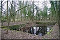
5
Roman River & The End of Footpath 128-1
The left side of the footbridge is the beginning of Footpath 129-49 that crosses the A12 and the mainline railway track to Kemp's Farm, where it should become footpath 132-11. However since the closure of the railway crossing there are lots of "Private no right of way" signs on the farm. however there is no sign of footpath diversion information the right of way The path is still shown on the Essex County Council electronic highways map see https://www.essexhighways.org/getting-around/public-rights-of-way/prow-interactive-map.aspx. There is a permissive path from the end of footpath 128-1 via Image The picture was taken looking downstream.
Image: © Glyn Baker
Taken: 15 Mar 2019
0.11 miles
8
Concrete "Tank" by Footpath 128-1
I wonder what the purpose was for this abandoned concrete tank.
Image: © Glyn Baker
Taken: 15 Mar 2019
0.14 miles
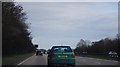
9
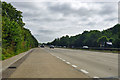
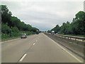
A12 Colchester Bypass
Looking east on the part that bypasses Copford and Stanway.
Image: © Robin Webster
Taken: 16 Jul 2016
0.19 miles
10
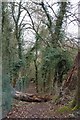
Fallen Log on Footpath 128-1
This footpath once led to Eight Ash Green but now you can only reach the A12 where the crossing
is Image
Image: © Glyn Baker
Taken: 15 Mar 2019
0.21 miles