IMAGES TAKEN NEAR TO
Turkey Cock Lane, COLCHESTER, CO3 8LX
Introduction
This page details the photographs taken nearby to Turkey Cock Lane, CO3 8LX by members of the Geograph project.
The Geograph project started in 2005 with the aim of publishing, organising and preserving representative images for every square kilometre of Great Britain, Ireland and the Isle of Man.

There are currently over 7.5m images from over14,400 individuals and you can help contribute to the project by visiting https://www.geograph.org.uk
Image Map
Images are licensed for reuse under creativecommons.org/licenses/by-sa/2.0
Notes
- Clicking on the map will re-center to the selected point.
- The higher the marker number, the further away the image location is from the centre of the postcode.
Image Listing (6 Images Found)
Images are licensed for reuse under creativecommons.org/licenses/by-sa/2.0
Image
Details
Distance
1
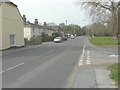
London Road, Copford
Seen from the junction with Turkey Cock Lane.
Image: © John Baker
Taken: 30 Mar 2014
0.03 miles
2
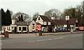
'The Swan' public house
It stands along the B1408, once the A12 and on course of the original Roman road between London and Colchester.
Image: © Robert Edwards
Taken: 10 Apr 2009
0.07 miles
3
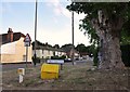
Turkey Cock Lane towards the Swan, Stanway
Looking towards the pub at the Stanway, Copford border
Image: © MJ Reilly
Taken: 6 Jul 2009
0.07 miles
4
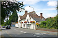
The White Hart, Stanway
Now a Toby Carvery.
Image: © Robin Webster
Taken: 16 Jul 2016
0.17 miles
5
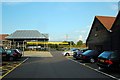
Chinese Restaurant Car Park, Stanway
On the same light industrial/retail site, among other outlets there is a garden centre, a Chinese restaurant and a pub/restaurant.
Image: © Trevor Harris
Taken: 27 Jun 2009
0.17 miles
6
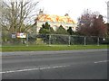
New Copford Place, London Road
A former residential care home, but now lying derelict, Copford Place is a grade II listed building, which dates from the 18th century but was altered in the early 19th century http://www.britishlistedbuildings.co.uk/england/essex/copford
Image: © John Baker
Taken: 30 Mar 2014
0.22 miles