IMAGES TAKEN NEAR TO
Lemur Lane, COLCHESTER, CO3 8BZ
Introduction
This page details the photographs taken nearby to Lemur Lane, CO3 8BZ by members of the Geograph project.
The Geograph project started in 2005 with the aim of publishing, organising and preserving representative images for every square kilometre of Great Britain, Ireland and the Isle of Man.

There are currently over 7.5m images from over14,400 individuals and you can help contribute to the project by visiting https://www.geograph.org.uk
Image Map
Images are licensed for reuse under creativecommons.org/licenses/by-sa/2.0
Notes
- Clicking on the map will re-center to the selected point.
- The higher the marker number, the further away the image location is from the centre of the postcode.
Image Listing (12 Images Found)
Images are licensed for reuse under creativecommons.org/licenses/by-sa/2.0
Image
Details
Distance
1
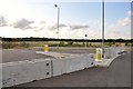
Undeveloped land, Tollgate, Colchester
Land between Tollgate and the A12, Stanway.
Image: © MJ Reilly
Taken: 6 Jul 2009
0.09 miles
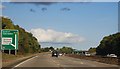
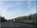
4
A12 Ipswich Road, Eight Ash Green
Approaching junction 26 Eight Ash Green at the junction with the A1124 Halstead Road
Image: © Geographer
Taken: 3 Aug 2014
0.16 miles
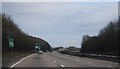
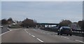
7
A12 overbridges for junction with A1124
Image: © Stuart Logan
Taken: 23 Jun 2013
0.22 miles
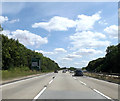
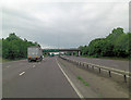
8
Bridges over A12 at Eight Ash Green junction
Image: © David Smith
Taken: 30 May 2017
0.22 miles

