IMAGES TAKEN NEAR TO
Ostrich Street, COLCHESTER, CO3 8AS
Introduction
This page details the photographs taken nearby to Ostrich Street, CO3 8AS by members of the Geograph project.
The Geograph project started in 2005 with the aim of publishing, organising and preserving representative images for every square kilometre of Great Britain, Ireland and the Isle of Man.

There are currently over 7.5m images from over14,400 individuals and you can help contribute to the project by visiting https://www.geograph.org.uk
Image Map
Images are licensed for reuse under creativecommons.org/licenses/by-sa/2.0
Notes
- Clicking on the map will re-center to the selected point.
- The higher the marker number, the further away the image location is from the centre of the postcode.
Image Listing (3 Images Found)
Images are licensed for reuse under creativecommons.org/licenses/by-sa/2.0
Image
Details
Distance
1
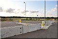
Undeveloped land, Tollgate, Colchester
Land between Tollgate and the A12, Stanway.
Image: © MJ Reilly
Taken: 6 Jul 2009
0.15 miles
2
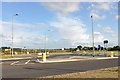
Towards Tollgate, Stanway
Link roads to the Tollgate Retail Park
Image: © MJ Reilly
Taken: 6 Jul 2009
0.23 miles
3
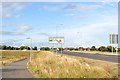
Essex Yeomanry Junction, Stanway
Looking towards the A12 link road by Tollgate.
Image: © MJ Reilly
Taken: 6 Jul 2009
0.23 miles