IMAGES TAKEN NEAR TO
Church Lane, COLCHESTER, CO3 4DX
Introduction
This page details the photographs taken nearby to Church Lane, CO3 4DX by members of the Geograph project.
The Geograph project started in 2005 with the aim of publishing, organising and preserving representative images for every square kilometre of Great Britain, Ireland and the Isle of Man.

There are currently over 7.5m images from over14,400 individuals and you can help contribute to the project by visiting https://www.geograph.org.uk
Image Map
Images are licensed for reuse under creativecommons.org/licenses/by-sa/2.0
Notes
- Clicking on the map will re-center to the selected point.
- The higher the marker number, the further away the image location is from the centre of the postcode.
Image Listing (10 Images Found)
Images are licensed for reuse under creativecommons.org/licenses/by-sa/2.0
Image
Details
Distance

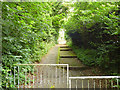
2
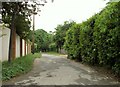
Public footpath to Blue Bottle Grove and Lexden Earthworks
Image: © Robert Edwards
Taken: 30 May 2008
0.08 miles
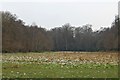
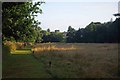
4
Autumn in Lexden Park
Lexden Park is a jewel that shines brightly among the urban sprawl of western Colchester.
Image: © Mr James D
Taken: 30 Oct 2004
0.14 miles
5

Former Murco site - Lexden
Corner of Church Lane and Heath Road, Lexden. This was once an orchard owned by A.G. Clarke of Heath Road. It was later used as a car hire site by the Tweed family of Lexden and subsequently became a petrol station. The site is now owned by Ark Vets of Church Lane.
Image: © J147
Taken: 2 Aug 2005
0.16 miles
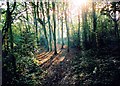
6

Lexden Dike
This is part of Colchester's Iron Age defences http://www.english-heritage.org.uk/daysout/properties/lexden-earthworks-and-bluebottle-grove/history-and-research/ see also Image
Image: © Glyn Baker
Taken: 23 Aug 2013
0.17 miles
7
Lexden Mount
A scheduled ancient monument, determined to be Roman from tiles found during a limited excavation in 1910.
Image: © Robin Webster
Taken: 2 Jul 2016
0.20 miles
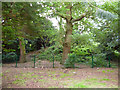
8
Footpath from Church Lane to Marlowe Way, Lexden
One of those short links that requires a close inspection of the map to be sure it is there. It is not marked as a public footpath on OS maps.
Image: © Robin Webster
Taken: 2 Jul 2016
0.21 miles
9
Morning in Lexden Park
An early stroll in http://www.geograph.org.uk/photo/3627134
Image: © Glyn Baker
Taken: 23 Aug 2013
0.22 miles
10

Bluebottle Grove, Colchester
This bank is an Iron Age earthwork that was part of the western defences of pre-roman Camvlodvnvm the capital for the Trinovantes tribe. The largest section of the Lexden earthworks still in existence is the Grymes Dyke see Image
Image: © Glyn Baker
Taken: 25 Mar 2006
0.23 miles