IMAGES TAKEN NEAR TO
Sheepen Place, COLCHESTER, CO3 3XL
Introduction
This page details the photographs taken nearby to Sheepen Place, CO3 3XL by members of the Geograph project.
The Geograph project started in 2005 with the aim of publishing, organising and preserving representative images for every square kilometre of Great Britain, Ireland and the Isle of Man.

There are currently over 7.5m images from over14,400 individuals and you can help contribute to the project by visiting https://www.geograph.org.uk
Image Map
Images are licensed for reuse under creativecommons.org/licenses/by-sa/2.0
Notes
- Clicking on the map will re-center to the selected point.
- The higher the marker number, the further away the image location is from the centre of the postcode.
Image Listing (94 Images Found)
Images are licensed for reuse under creativecommons.org/licenses/by-sa/2.0
Image
Details
Distance
1
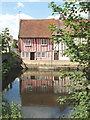
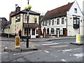
Cottages by the River Colne, Colchester
These half-timbered cottages are by the Station Road bridge.
Image: © David Hawgood
Taken: 15 Jun 2006
0.05 miles
4
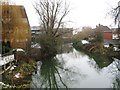
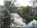
The River Colne from North Station Road Colchester
Image: © Roy Hughes
Taken: 14 Oct 2023
0.07 miles
6
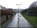
Balkerne Hill
Balkerne Hill looking north on a wet day at Colchester, Essex.
Image: © Keith Evans
Taken: 16 Feb 2010
0.08 miles
7
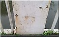
Ordnance Survey Cut Mark
This OS cut mark can be found on the west parapet of the bridge. It marks a point 8.700m above mean sea level.
Image: © Adrian Dust
Taken: 8 Jan 2020
0.09 miles
8
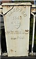
Old Bridge Marker on North Bridge, North Station Road, Colchester
Bridge Marker by the UC Road, in parish of Colchester (Colchester District), North Bridge, River Colne, in West parapet.
Inscription reads:-
ERECTED
1843.
{coat of arms}
Rᴿ.NUNN.MD
MAYOR
North Bridge is Grade II listed.
List Entry Number: 1278579 https://historicengland.org.uk/listing/the-list/list-entry/1278579
Surveyed
Milestone Society National ID: EX_COLC07br
Image: © Milestone Society
Taken: Unknown
0.09 miles
9
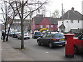
North Station Road, CO1
Shows the location of Image
Image: © Mike Quinn
Taken: 2 Apr 2014
0.09 miles
10
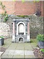
Drinking Fountain
This fountain was situated at the entrance to the town cattle market in Middleborough. On the closure of the market and its subsequent redevelopment the fountain was moved to its present location under the shadow of the town's Roman Wall.
Image: © Peter Pearson
Taken: 20 May 2019
0.10 miles