IMAGES TAKEN NEAR TO
Audley Road, COLCHESTER, CO3 3TZ
Introduction
This page details the photographs taken nearby to Audley Road, CO3 3TZ by members of the Geograph project.
The Geograph project started in 2005 with the aim of publishing, organising and preserving representative images for every square kilometre of Great Britain, Ireland and the Isle of Man.

There are currently over 7.5m images from over14,400 individuals and you can help contribute to the project by visiting https://www.geograph.org.uk
Image Map
Images are licensed for reuse under creativecommons.org/licenses/by-sa/2.0
Notes
- Clicking on the map will re-center to the selected point.
- The higher the marker number, the further away the image location is from the centre of the postcode.
Image Listing (8 Images Found)
Images are licensed for reuse under creativecommons.org/licenses/by-sa/2.0
Image
Details
Distance
1
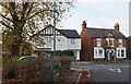
Drury Road at the junction of Maldon Road, Colchester
A drinking trough is on the left.
Image: © David Howard
Taken: 27 Oct 2024
0.10 miles
3
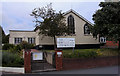
New Church Colchester Essex
Situated in Maldon Road. New Church is part of the General Church of the New Jerusalem.
Image: © Peter Stack
Taken: 22 Jun 2009
0.19 miles
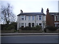
4
Marylands surgery on Shrub End Road
It's called a wellbeing hub, otherwise called a surgery.
Image: © David Howard
Taken: 23 Feb 2019
0.20 miles
5
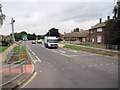
Boadicea Way from Shrub End road junction
Image: © John Firth
Taken: 14 Sep 2010
0.21 miles
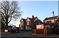
6
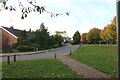
Irvine Road Field, Lexden
By Landseer Road
Image: © David Howard
Taken: 27 Oct 2024
0.22 miles
7
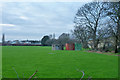
Pillbox on playing field, Colchester
One of very many that were arrayed around the garrison town.
Image: © Robin Webster
Taken: 17 Jan 2016
0.24 miles
8

Landseer Road, Lexden
Typical 1960s bungalows.
Image: © David Howard
Taken: 27 Oct 2024
0.25 miles