IMAGES TAKEN NEAR TO
Endsleigh Court, COLCHESTER, CO3 3QT
Introduction
This page details the photographs taken nearby to Endsleigh Court, CO3 3QT by members of the Geograph project.
The Geograph project started in 2005 with the aim of publishing, organising and preserving representative images for every square kilometre of Great Britain, Ireland and the Isle of Man.

There are currently over 7.5m images from over14,400 individuals and you can help contribute to the project by visiting https://www.geograph.org.uk
Image Map
Images are licensed for reuse under creativecommons.org/licenses/by-sa/2.0
Notes
- Clicking on the map will re-center to the selected point.
- The higher the marker number, the further away the image location is from the centre of the postcode.
Image Listing (16 Images Found)
Images are licensed for reuse under creativecommons.org/licenses/by-sa/2.0
Image
Details
Distance
3
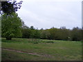
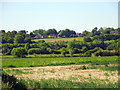
Hillyfields Nature Reserve, Colchester
Taken from the entrance in Sussex Street
Image: © PAUL FARMER
Taken: 9 May 2010
0.12 miles
5
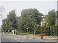
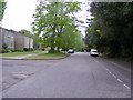
Lexden Road (A1124) (2)
Shows the location of Image
Image: © Mike Quinn
Taken: 2 Apr 2014
0.18 miles
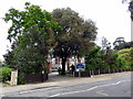
6
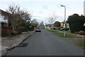
Houses on Lexden Road (A1124)
Shows the location of Image
Image: © Mike Quinn
Taken: 2 Apr 2014
0.19 miles
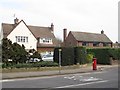
7
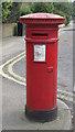
"Anonymous" (Victorian) postbox, Lexden Road (A1124) / Ashley Gardens, CO3
The low posting aperture dates this postbox to 1883-87. The location of this postbox is shown in Image, Image and Image
Image: © Mike Quinn
Taken: 2 Apr 2014
0.19 miles