IMAGES TAKEN NEAR TO
Manor Road, COLCHESTER, CO3 3LU
Introduction
This page details the photographs taken nearby to Manor Road, CO3 3LU by members of the Geograph project.
The Geograph project started in 2005 with the aim of publishing, organising and preserving representative images for every square kilometre of Great Britain, Ireland and the Isle of Man.

There are currently over 7.5m images from over14,400 individuals and you can help contribute to the project by visiting https://www.geograph.org.uk
Image Map
Images are licensed for reuse under creativecommons.org/licenses/by-sa/2.0
Notes
- Clicking on the map will re-center to the selected point.
- The higher the marker number, the further away the image location is from the centre of the postcode.
Image Listing (126 Images Found)
Images are licensed for reuse under creativecommons.org/licenses/by-sa/2.0
Image
Details
Distance
1
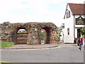
Balkerne Gate, Colchester
The largest Roman arch in Britain. Colchester and its wall were rebuilt by the Romans after Queen Boudica led a rebellion in AD 60 and destroyed the town.
Image: © David Hawgood
Taken: 15 Jun 2006
0.04 miles
2
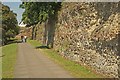
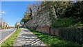
Roman wall, Colchester
The oldest town wall in England. Two thirds of the wall built by the Romans still remains. This is the western section by Balkerne Hill and Image
Image: © David Hawgood
Taken: 15 Jun 2006
0.04 miles
3
Roman City Wall, Colchester
https://historicengland.org.uk/listing/the-list/list-entry/1003772?section=official-list-entry
Image: © Sandy Gerrard
Taken: 20 Apr 2023
0.05 miles
4
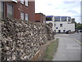
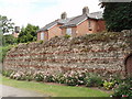
Embassy Oriental Buffet, Balkerne Hill, Colchester
The picture also shows part of the Roman Town Wall
Image: © PAUL FARMER
Taken: 5 Aug 2010
0.05 miles
5
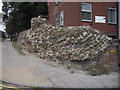
Part of Roman Wall near Balkerne Hill, Colchester
Image: © PAUL FARMER
Taken: 5 Aug 2010
0.05 miles
6
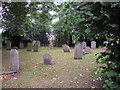
Gravestones in grounds of St Mary's Church, Colchester
St Mary's Church is now the Colchester Arts Centre
Image: © PAUL FARMER
Taken: 5 Aug 2010
0.05 miles
7
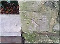
Ordnance Survey 1GL Bolt
This OS Bolt can be found on the NW angle of St Mary's Church. It marks a point 34.680m above mean sea level.
Image: © Adrian Dust
Taken: 7 Jan 2020
0.06 miles
8
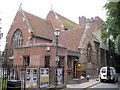
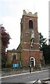
St Mary's Church, Church Lane Colchester
The church has been The Colchester Arts Centre since 1980. The Church is built against the Roman Walls and overlooking the western suburbs of the town. It was first recorded in 1206, the church has a notable history. It is the site at which 23 Protestant martyrs were executed by burning during the reign of the Mary I ("Bloody Mary"). During the English Civil War the church tower was used as a gun emplacement by the Royalist army, this resulted in its destruction by New Model Army siege batteries. The tower of the Norman church remains, the rest was rebuilt in red brick in 1713. There was a further major rebuild in 1872. In 1978, the parish was united with Christ Church, St Mary's became redundant; the bell went to St Leonard's in Lexden and the organ to Brentwood Cathedral.
Image: © PAUL FARMER
Taken: 5 Aug 2010
0.07 miles