IMAGES TAKEN NEAR TO
Heath Road, COLCHESTER, CO3 0QR
Introduction
This page details the photographs taken nearby to Heath Road, CO3 0QR by members of the Geograph project.
The Geograph project started in 2005 with the aim of publishing, organising and preserving representative images for every square kilometre of Great Britain, Ireland and the Isle of Man.

There are currently over 7.5m images from over14,400 individuals and you can help contribute to the project by visiting https://www.geograph.org.uk
Image Map
Images are licensed for reuse under creativecommons.org/licenses/by-sa/2.0
Notes
- Clicking on the map will re-center to the selected point.
- The higher the marker number, the further away the image location is from the centre of the postcode.
Image Listing (5 Images Found)
Images are licensed for reuse under creativecommons.org/licenses/by-sa/2.0
Image
Details
Distance
1
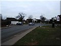
Fiveways Stanway
This area of Stanway is named Fiveways after this junction where Winstree, Heath, Peartree, Dyers & Blackberry roads meet. The photo was taken looking west From Peartree Rd into Blackberry Rd. Winstree Rd is to the right and Heath Rd to the left. Dyers Rd is to the left after the zebra crossing.
Image: © Glyn Baker
Taken: 5 Feb 2006
0.09 miles
2
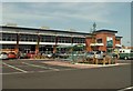
Co-op Supermarket in Peartree Road, Stanway
Image: © Robert Edwards
Taken: 5 May 2008
0.11 miles
3
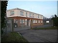
Anglian Water Services, Shrub End
This is the local offices of Anglian Water Services in Dugard Avenue Shrub End Colchester
Image: © Glyn Baker
Taken: 2 Jan 2006
0.18 miles
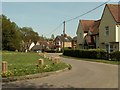
5

Stanway Green
Born and bred in Colchester & I never knew this "Village Green" existed until today.
Image: © Glyn Baker
Taken: 14 Mar 2019
0.24 miles