IMAGES TAKEN NEAR TO
Peace Road, COLCHESTER, CO3 0HL
Introduction
This page details the photographs taken nearby to Peace Road, CO3 0HL by members of the Geograph project.
The Geograph project started in 2005 with the aim of publishing, organising and preserving representative images for every square kilometre of Great Britain, Ireland and the Isle of Man.

There are currently over 7.5m images from over14,400 individuals and you can help contribute to the project by visiting https://www.geograph.org.uk
Image Map
Images are licensed for reuse under creativecommons.org/licenses/by-sa/2.0
Notes
- Clicking on the map will re-center to the selected point.
- The higher the marker number, the further away the image location is from the centre of the postcode.
Image Listing (39 Images Found)
Images are licensed for reuse under creativecommons.org/licenses/by-sa/2.0
Image
Details
Distance
1
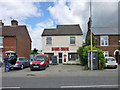
Royal Mail Delivery Office
50 London Road is a remarkably unpretentious building, it appears to have once been an ordinary sub post office.
Image: © Robin Webster
Taken: 2 Jul 2016
0.07 miles


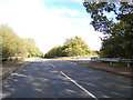
4

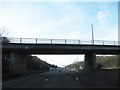
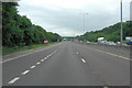
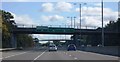
A12 Colchester Bypass at Stanway
A bridge carrying Halstead Road can be seen crossing the A12 in the middle distance.
Image: © Matthew Barker
Taken: 28 Aug 2006
0.10 miles

6
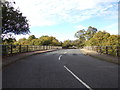
Halstead Road, Beacon End, Colchester
At the junction with Stan Way
Image: © Geographer
Taken: 5 Oct 2019
0.11 miles