IMAGES TAKEN NEAR TO
Tyed Croft, COLCHESTER, CO3 0GH
Introduction
This page details the photographs taken nearby to Tyed Croft, CO3 0GH by members of the Geograph project.
The Geograph project started in 2005 with the aim of publishing, organising and preserving representative images for every square kilometre of Great Britain, Ireland and the Isle of Man.

There are currently over 7.5m images from over14,400 individuals and you can help contribute to the project by visiting https://www.geograph.org.uk
Image Map
Images are licensed for reuse under creativecommons.org/licenses/by-sa/2.0
Notes
- Clicking on the map will re-center to the selected point.
- The higher the marker number, the further away the image location is from the centre of the postcode.
Image Listing (14 Images Found)
Images are licensed for reuse under creativecommons.org/licenses/by-sa/2.0
Image
Details
Distance
1
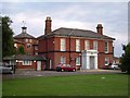
Stanway Spike
"The Spike" was a pejorative term for a “Workhouse” (social welfare 19th century style). In the second half of the 20th century this former workhouse became St Albrights local authority old people’s home. The building is no longer residential but remains the centre for the local Social Services care of the elderly teams.
Image: © Glyn Baker
Taken: 20 Aug 2005
0.09 miles
2
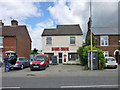
Royal Mail Delivery Office
50 London Road is a remarkably unpretentious building, it appears to have once been an ordinary sub post office.
Image: © Robin Webster
Taken: 2 Jul 2016
0.16 miles

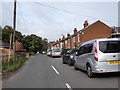
4
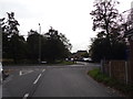
King Cole Road, Beacon End
At the junction with the A1124 London Road
Image: © Geographer
Taken: 4 Oct 2019
0.18 miles


7
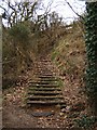
Gryme's Dyke
These steps climb up Gryme's Dyke part of the Iron Age Lexden Earthworks. Gryme's Dyke survives over a three-mile long stretch. The earthworks defended Camvlodvnvm; they were taken over and improved by the Romans. You can see another part of the network of defences at Image
Image: © Glyn Baker
Taken: 25 Mar 2006
0.20 miles
9
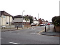
Collingwood Road, Beacon End
At the junction with the A1124 London Road
Image: © Geographer
Taken: 4 Oct 2019
0.21 miles
10
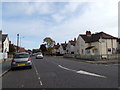
A1124 London Road, Beacon End
At the junction with Collingwood Road
Image: © Geographer
Taken: 4 Oct 2019
0.22 miles