IMAGES TAKEN NEAR TO
Eight Acre Lane, COLCHESTER, CO2 9LS
Introduction
This page details the photographs taken nearby to Eight Acre Lane, CO2 9LS by members of the Geograph project.
The Geograph project started in 2005 with the aim of publishing, organising and preserving representative images for every square kilometre of Great Britain, Ireland and the Isle of Man.

There are currently over 7.5m images from over14,400 individuals and you can help contribute to the project by visiting https://www.geograph.org.uk
Image Map
Images are licensed for reuse under creativecommons.org/licenses/by-sa/2.0
Notes
- Clicking on the map will re-center to the selected point.
- The higher the marker number, the further away the image location is from the centre of the postcode.
Image Listing (5 Images Found)
Images are licensed for reuse under creativecommons.org/licenses/by-sa/2.0
Image
Details
Distance
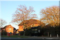
1
New housing estate on Layer Road, Colchester
Image: © David Howard
Taken: 23 Feb 2019
0.19 miles
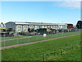
2
Playing fields in Colchester
The goalposts here have some camouflage netting over instead of the usual onion bag goal netting. It's adjacent to the military garrison.
Image: © Jeremy Bolwell
Taken: 22 Jan 2017
0.20 miles
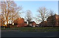
3
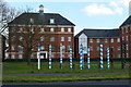
Modern apartments seen across Layer Road
The painted posts form a diverting feature, but their significance is not apparent to (this) passer-by.
Image: © David Martin
Taken: 28 Mar 2017
0.20 miles