IMAGES TAKEN NEAR TO
Bishop Road, COLCHESTER, CO2 9DN
Introduction
This page details the photographs taken nearby to Bishop Road, CO2 9DN by members of the Geograph project.
The Geograph project started in 2005 with the aim of publishing, organising and preserving representative images for every square kilometre of Great Britain, Ireland and the Isle of Man.

There are currently over 7.5m images from over14,400 individuals and you can help contribute to the project by visiting https://www.geograph.org.uk
Image Map
Images are licensed for reuse under creativecommons.org/licenses/by-sa/2.0
Notes
- Clicking on the map will re-center to the selected point.
- The higher the marker number, the further away the image location is from the centre of the postcode.
Image Listing (10 Images Found)
Images are licensed for reuse under creativecommons.org/licenses/by-sa/2.0
Image
Details
Distance
1
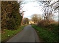
Paxman Avenue
This street is named after the eminent Victorian James Noah Paxman who co-founded the Standard Iron Works in Colchester in 1865. Paxmans was a major employer in the town until the late 1980/90s. It was Paxmans who made the engines for the HS125 diesel locomotives. MAN Diesel still have a small presence in the town on the former Paxmans site
Image: © Glyn Baker
Taken: 23 Aug 2013
0.14 miles
3

Morris Garages, Shrub End
An MG dealership in Colchester one of the few parts of the once mighty British Motor Corporation that still exists, be it in name only.
Image: © Glyn Baker
Taken: 23 Aug 2013
0.17 miles
4

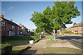
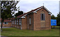
Gosbecks Primary School
"Schools out for summer!"
Image: © Glyn Baker
Taken: 23 Aug 2013
0.17 miles
5
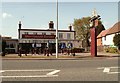
'Huntsmans Tavern' public house
It stands alongside the B1022.
Image: © Robert Edwards
Taken: 16 Apr 2008
0.18 miles
6
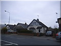
St Cedd Church Colchester Essex
Situated at the junction of Walnut Tree Way and Eldred Avenue.
Image: © Peter Stack
Taken: 22 Jun 2009
0.18 miles
7
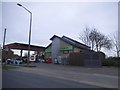
Texaco petrol station on Shrub End Road
Image: © David Howard
Taken: 4 Apr 2017
0.21 miles
8
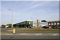
Lidl Supermarket, Gosbecks Road, Colchester
Image: © Martin Tester
Taken: 22 Sep 2022
0.24 miles
9
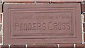
Old Wayside Cross plaque by the B1022, Shrub End Road, Lexden
Pedders Cross plaque, replaces older cross by the B1022, in parish of Colchester (Colchester District), set in front wall of 256 Shrub End Road, Lexden, next to Gosbecks Road, set in the front wall of Church Cottage.
Inscription reads:-
AT THIS CORNER STOOD
PEDDERS CROSS
Colchester HER request any information about Pedders Cross.
https://www.heritagegateway.org.uk/Gateway/Results_Single.aspx?uid=MCC2290&resourceID=1011
Surveyed
Milestone Society National ID: EXCO_LEX03
Image: © Milestone Society
Taken: Unknown
0.24 miles