IMAGES TAKEN NEAR TO
Rayner Road, COLCHESTER, CO2 9AF
Introduction
This page details the photographs taken nearby to Rayner Road, CO2 9AF by members of the Geograph project.
The Geograph project started in 2005 with the aim of publishing, organising and preserving representative images for every square kilometre of Great Britain, Ireland and the Isle of Man.

There are currently over 7.5m images from over14,400 individuals and you can help contribute to the project by visiting https://www.geograph.org.uk
Image Map
Images are licensed for reuse under creativecommons.org/licenses/by-sa/2.0
Notes
- Clicking on the map will re-center to the selected point.
- The higher the marker number, the further away the image location is from the centre of the postcode.
Image Listing (5 Images Found)
Images are licensed for reuse under creativecommons.org/licenses/by-sa/2.0
Image
Details
Distance
1
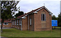
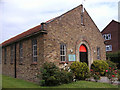
St Cedd Church Colchester Essex
Situated at the junction of Walnut Tree Way and Eldred Avenue.
Image: © Peter Stack
Taken: 22 Jun 2009
0.16 miles
3
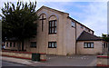
United Reformed Church Colchester Essex
Situated in Plume Avenue.
Image: © Peter Stack
Taken: 22 Jun 2009
0.20 miles
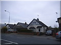
4
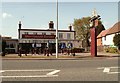
'Huntsmans Tavern' public house
It stands alongside the B1022.
Image: © Robert Edwards
Taken: 16 Apr 2008
0.22 miles
5
St John the Baptist RC Church Colchester Essex
Situated in Iceni Way.
Image: © Peter Stack
Taken: 22 Jun 2009
0.24 miles