IMAGES TAKEN NEAR TO
Roosevelt Way, COLCHESTER, CO2 8SP
Introduction
This page details the photographs taken nearby to Roosevelt Way, CO2 8SP by members of the Geograph project.
The Geograph project started in 2005 with the aim of publishing, organising and preserving representative images for every square kilometre of Great Britain, Ireland and the Isle of Man.

There are currently over 7.5m images from over14,400 individuals and you can help contribute to the project by visiting https://www.geograph.org.uk
Image Map
Images are licensed for reuse under creativecommons.org/licenses/by-sa/2.0
Notes
- Clicking on the map will re-center to the selected point.
- The higher the marker number, the further away the image location is from the centre of the postcode.
Image Listing (45 Images Found)
Images are licensed for reuse under creativecommons.org/licenses/by-sa/2.0
Image
Details
Distance
1
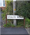
Street-name sign, Stalin Road
Quite a surprise to find that Colchester hasn't air-brushed Stalin out of history. Uncle Joe would have shown no such tender regard for those who resisted him.
Image: © Stefan Czapski
Taken: 5 Sep 2015
0.02 miles
2
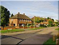
Roosevelt Way, Colchester
Seen from the corner of Stalin Road.
Image: © Stefan Czapski
Taken: 5 Sep 2015
0.03 miles
3
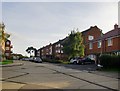
Stalin Road, Colchester
Looking south from the corner of Roosevelt Way.
The street-names must - I suppose - date from the time of the Yalta agreement.
Image: © Stefan Czapski
Taken: 5 Sep 2015
0.04 miles
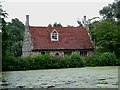
6

Bourne Mill - Entrance
The bottom entrance into the pit wheel area.
Image: © Ashley Dace
Taken: 26 Aug 2012
0.10 miles
7

Bourne Mill - Stone Construction
The construction is made up of Roman tiles, odd bits of limestone and flint. A real jumble!
Image: © Ashley Dace
Taken: 26 Aug 2012
0.10 miles
8

Bourne Mill - Entrance
The entrance into the mill with the entrance for water being the leat to the bottom right. Note the random make-up of the construction stones, mostly limestone blocks, Roman tile and flint.
Image: © Ashley Dace
Taken: 26 Aug 2012
0.10 miles
9
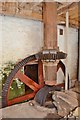
Bourne Mill - pit wheel and wallower
The pit wheel and wallower with nothing in the way to ruin it for photographers.
Image: © Ashley Dace
Taken: 26 Aug 2012
0.10 miles
10
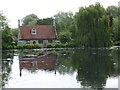
Bourne Mill
Bourne Mill built in 1591 by Flemish settlers as a fishing lodge, it was later converted into a mill. Owned by the National Trust the wheel and internal machinery have been restored.
Image: © Glyn Baker
Taken: 13 Aug 2005
0.10 miles