IMAGES TAKEN NEAR TO
Bourne Road, COLCHESTER, CO2 8RS
Introduction
This page details the photographs taken nearby to Bourne Road, CO2 8RS by members of the Geograph project.
The Geograph project started in 2005 with the aim of publishing, organising and preserving representative images for every square kilometre of Great Britain, Ireland and the Isle of Man.

There are currently over 7.5m images from over14,400 individuals and you can help contribute to the project by visiting https://www.geograph.org.uk
Image Map
Images are licensed for reuse under creativecommons.org/licenses/by-sa/2.0
Notes
- Clicking on the map will re-center to the selected point.
- The higher the marker number, the further away the image location is from the centre of the postcode.
Image Listing (51 Images Found)
Images are licensed for reuse under creativecommons.org/licenses/by-sa/2.0
Image
Details
Distance
2
Entrance to Bourne Valley Nature reserve
Image: © PAUL FARMER
Taken: 15 May 2016
0.04 miles
4
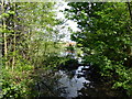
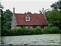
Bourne Mill - Mill pond
The mill pond provides plenty of power to the breastshot wheel.
Image: © Ashley Dace
Taken: 26 Aug 2012
0.05 miles
5
Bourne Mill
Bourne Mill built in 1591 by Flemish settlers as a fishing lodge, it was later converted into a mill. Owned by the National Trust the wheel and internal machinery have been restored.
Image: © Glyn Baker
Taken: 13 Aug 2005
0.06 miles
6
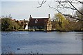
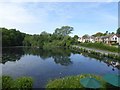
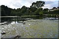
Bourne Pond
This is Bourne Pond with Image on the far side this is a National Trust property see http://nationaltrust.org.uk/main/w-vh/w-visits/w-findaplace/w-bournemill/
Image: © Glyn Baker
Taken: 18 Mar 2007
0.06 miles
7
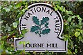
National Trust Sign
National Trust sign for Bourne Mill near to Old Heath, Essex.
Image: © Keith Evans
Taken: 16 Sep 2015
0.07 miles
8
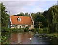
Bourne Mill from the west
The photo was taken on a brief evening visit, from public space (in Bourne Road) rather than from within the National Trust grounds. I chose the angle in the hope of showing the building's most distinctive features: the elaborate gables, with their array of pinnacles.
Not a great deal seems to be known about the building's origins, but a tablet set in the south gable is inscribed 'Thomas Lucas, miles, me fecit Anne Domini 1591'. So it seems its builder was a soldier. I've seen it suggested that Lucas was of Dutch or Flemish origin - which could well explain the fantastical gables. Whatever his origins, Lucas's design strikes me as very un-English - unlike almost anything in England other than Image
The mill stands on a bank which dams a stream known as the Bourne. At one stage in its history the pond served as a fish-pond for the local abbey, but it isn't clear whether the pond was constructed for that purpose or to serve an earlier mill. In any case, the consensus is that Lucas's building was intended as a fishing lodge, not for any industrial purpose: http://www.colchesterhistoricbuildingsforum.org.uk/drupal/node/251
Image: © Stefan Czapski
Taken: 5 Sep 2015
0.07 miles
9

Bourne Mill - Grain Store
The roof space is now home to art and a few information panels.
Image: © Ashley Dace
Taken: 26 Aug 2012
0.07 miles
10
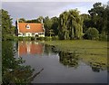
Bourne Mill and millpond
The mill is a National Trust property, but I arrived after closing time in the evening, so this photo was taken from the street (Bourne Road).
The little building dates from 1591, and the consensus seems to be that it was built as a fishing lodge. Image shows a closer view - and includes some thoughts on the building's history.
Image: © Stefan Czapski
Taken: 5 Sep 2015
0.07 miles