IMAGES TAKEN NEAR TO
Commerce Way, COLCHESTER, CO2 8HY

Introduction

This page details the photographs taken nearby to Commerce Way, CO2 8HY by members of the Geograph project.

The Geograph project started in 2005 with the aim of publishing, organising and preserving representative images for every square kilometre of Great Britain, Ireland and the Isle of Man.

There are currently over 7.5m images from over14,400 individuals and you can help contribute to the project by visiting https://www.geograph.org.uk

Image Map


Images are licensed for reuse under creativecommons.org/licenses/by-sa/2.0
Notes
  • Clicking on the map will re-center to the selected point.
  • The higher the marker number, the further away the image location is from the centre of the postcode.

Image Listing (26 Images Found)

Images are licensed for reuse under creativecommons.org/licenses/by-sa/2.0
  • ...
Image
Details
Distance
1
Old Heath, Colchester
Image: © terry joyce Taken: 18 Aug 2010
0.09 miles
2
Coldock 1975
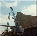
This is a picture of the Coldock (The Colchester Dock Transport Company) grain silo and cranes. The picture was taken in 1975 as part of a CSE project. The picture was taken looking downstream. You can see the view thirty-two years on at Image
Image: © Glyn Baker Taken: Unknown
0.12 miles
3
Haven Road Hythe Colchester
Image: © PAUL FARMER Taken: 6 Feb 2010
0.17 miles
4
'Niagara' at King Edward Quay, Colchester
This continental canal barge has been moored here a long time, presumably a house boat.
Image: © Robin Webster Taken: 9 Feb 2019
0.19 miles
5
Anti Rabies Sign
An old anti Rabies precautions sign on the wall of the Colchester Dock Transit Company. It clearly indicates that there was much traffic to the Baltic in the days when the dock was operational.
Image: © Glyn Baker Taken: 19 May 2007
0.19 miles
6
Coldock Revisited
This is the Colchester Dock Transit Company site as it is today, the warehouses are derelict and waiting for redevelopment. Thirty-two years ago it was a thriving independent dock see Image
Image: © Glyn Baker Taken: 19 May 2007
0.19 miles
7
Moored boats, Colchester
Most of the boats, particularly towards this end of the quay, are either houseboats or derelict.
Image: © Robin Webster Taken: 9 Feb 2019
0.19 miles
8
Sign Haven Road Colchester
The buildings in the distance are in Wivenhoe Park and are student accommodation.
Image: © PAUL FARMER Taken: 6 Feb 2010
0.20 miles
9
Redundant quayside at The Hythe
Colchester's port closed in 2001, and the warehouses are derelict. A local plan to regenerate the area is slowly taking shape.
Image: © Bob Jones Taken: 24 Jun 2008
0.20 miles
10
Haven Road, the Hythe, Colchester
Image: © Robin Webster Taken: 9 Feb 2019
0.21 miles
  • ...