IMAGES TAKEN NEAR TO
Rowhedge Road, COLCHESTER, CO2 8EJ
Introduction
This page details the photographs taken nearby to Rowhedge Road, CO2 8EJ by members of the Geograph project.
The Geograph project started in 2005 with the aim of publishing, organising and preserving representative images for every square kilometre of Great Britain, Ireland and the Isle of Man.

There are currently over 7.5m images from over14,400 individuals and you can help contribute to the project by visiting https://www.geograph.org.uk
Image Map
Images are licensed for reuse under creativecommons.org/licenses/by-sa/2.0
Notes
- Clicking on the map will re-center to the selected point.
- The higher the marker number, the further away the image location is from the centre of the postcode.
Image Listing (7 Images Found)
Images are licensed for reuse under creativecommons.org/licenses/by-sa/2.0
Image
Details
Distance
1
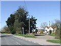
Cleavelands, near Rowhedge
Cleavelands, set back from the road.
Image: © Malc McDonald
Taken: 20 Apr 2013
0.02 miles
2
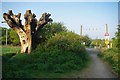
Old Oak & Crossing
It is a shame this old oak on the north side of Image is now only beetle food.
Image: © Glyn Baker
Taken: 24 Apr 2011
0.12 miles
3
View north from Rowhedge Road
Looking towards the University of Essex.
Image: © Robin Webster
Taken: 28 Nov 2017
0.15 miles
4
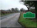
The Edge of Rowhedge
This is the point on Rowhedge Rd where Old Heath becomes Rowhedge. The photo was taken looking towards the South-East.
Image: © Glyn Baker
Taken: 2 Jan 2006
0.20 miles
5
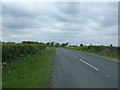
Rowhedge Road
Looking north west near Battleswick Farm.
Image: © JThomas
Taken: 27 Apr 2017
0.20 miles
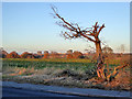
6
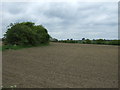
Field near Battleswick Farm
Off Rowhedge Road.
Image: © JThomas
Taken: 27 Apr 2017
0.21 miles
7
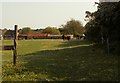
Looking across a field to Battleswick Farm
Image: © Robert Edwards
Taken: 14 May 2008
0.22 miles