IMAGES TAKEN NEAR TO
Old Heath Road, COLCHESTER, CO2 8AU
Introduction
This page details the photographs taken nearby to Old Heath Road, CO2 8AU by members of the Geograph project.
The Geograph project started in 2005 with the aim of publishing, organising and preserving representative images for every square kilometre of Great Britain, Ireland and the Isle of Man.

There are currently over 7.5m images from over14,400 individuals and you can help contribute to the project by visiting https://www.geograph.org.uk
Image Map
Images are licensed for reuse under creativecommons.org/licenses/by-sa/2.0
Notes
- Clicking on the map will re-center to the selected point.
- The higher the marker number, the further away the image location is from the centre of the postcode.
Image Listing (16 Images Found)
Images are licensed for reuse under creativecommons.org/licenses/by-sa/2.0
Image
Details
Distance
1
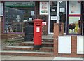
George V postbox on, Old Heath Convenience Store and Post Office
On Old Heath Road.
Postbox No. CO2 295.
See Image] for context.
Image: © JThomas
Taken: 27 Apr 2017
0.02 miles
2
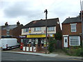
Old Heath Convenience Store and Post Office
On Old Heath Road.
Postbox No. CO2 295.
See Image] for postbox.
Image: © JThomas
Taken: 27 Apr 2017
0.02 miles
4
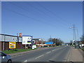
Whitehall Road, The Hythe, near Colchester
Whitehall Road passing through an industrial area on the outskirts of Colchester.
Image: © Malc McDonald
Taken: 20 Apr 2013
0.08 miles
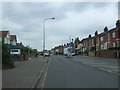
5
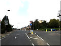
Old Heath Road
At the junction with Whitehall Road
Image: © Geographer
Taken: 3 Oct 2015
0.08 miles
6
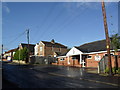
Old Heath Community Centre
In D'Arcy Road.
Image: © Burgess Von Thunen
Taken: 26 Oct 2011
0.12 miles
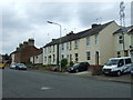
7

Postie
Old Heath Road in Old Heath.
Image: © Burgess Von Thunen
Taken: 3 Jul 2012
0.14 miles
9
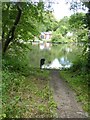
Distillery Pond, Colchester
Pool for the former mills
Image: © David Smith
Taken: 31 May 2017
0.17 miles
10

Distillery Pond
This is the third mill site on the Bourne Brook, first Image, then Image and lastly is Distillery Pond. From before WW2 until recently the mill site was home to a laundry. This survived until a few years ago. The whole area below the dam is now a housing development.
Image: © Glyn Baker
Taken: 19 May 2007
0.19 miles