IMAGES TAKEN NEAR TO
CO2 7WF
Introduction
This page details the photographs taken nearby to CO2 7WF by members of the Geograph project.
The Geograph project started in 2005 with the aim of publishing, organising and preserving representative images for every square kilometre of Great Britain, Ireland and the Isle of Man.

There are currently over 7.5m images from over14,400 individuals and you can help contribute to the project by visiting https://www.geograph.org.uk
Image Map
Images are licensed for reuse under creativecommons.org/licenses/by-sa/2.0
Notes
- Clicking on the map will re-center to the selected point.
- The higher the marker number, the further away the image location is from the centre of the postcode.
Image Listing (28 Images Found)
Images are licensed for reuse under creativecommons.org/licenses/by-sa/2.0
Image
Details
Distance
1
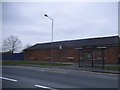
Derelict block of Colchester Garrison
Most of this area has already been demolished for new housing, this is the last remaining part standing on this end.
Image: © David Howard
Taken: 4 Apr 2017
0.14 miles

5
Merrils in Butt Rd
This is Butt Road Colchester near the Old Cavalry Barracks. The shop is Merrill’s an independent electrical goods retailer advertised by Image
Image: © Glyn Baker
Taken: 15 Apr 2006
0.16 miles
6

Dyson Man
Is it a bird? Is it a plane? No its……….. DYSON MAN! outside Image
Image: © Glyn Baker
Taken: 15 Apr 2006
0.16 miles
7
Maldon Road, Colchester
At the end of Oxford Road
Image: © David Howard
Taken: 27 Oct 2024
0.16 miles