IMAGES TAKEN NEAR TO
Circular Road South, COLCHESTER, CO2 7UA
Introduction
This page details the photographs taken nearby to Circular Road South, CO2 7UA by members of the Geograph project.
The Geograph project started in 2005 with the aim of publishing, organising and preserving representative images for every square kilometre of Great Britain, Ireland and the Isle of Man.

There are currently over 7.5m images from over14,400 individuals and you can help contribute to the project by visiting https://www.geograph.org.uk
Image Map
Images are licensed for reuse under creativecommons.org/licenses/by-sa/2.0
Notes
- Clicking on the map will re-center to the selected point.
- The higher the marker number, the further away the image location is from the centre of the postcode.
Image Listing (11 Images Found)
Images are licensed for reuse under creativecommons.org/licenses/by-sa/2.0
Image
Details
Distance
1
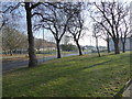
Scene near Merville Barracks, Colchester
A lovely avenue of trees and the corner of a park.
Image: © Jeremy Bolwell
Taken: 22 Jan 2017
0.07 miles
2
Douglas Dakota in Operation Overlord livery gate guardian
Restricted image because I was not permitted to set foot onto the Colchester Garrison but I was grateful for the opportunity to grab a quickie under the watchful eye of the armed guard.
Image: © Adrian S Pye
Taken: 13 Feb 2017
0.13 miles
3
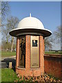
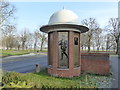
Memorial of Colchester's Goojerat Garrison
The military acquired the land at Barn Hill Farm, Colchester in 1899 and built the garrison which they named after the First (Goojerat) and Second (Sobraon) Sikh Wars of 1846 and 1849 respectively. The Garrison was first occupied by troops in 1900.
In the 18th century troops were accommodated in local billeting or in temporary camps.
A more permanent accommodation was erected for the French Wars, 1793 - 1815 but was disposed of after the war. The Crimean War, 1854 - 1856 saw hutted accommodation built on what was called Ordnance Field.
Goojerat and Sobraon Barracks are now known as Blenheim Park.
Image: © Adrian S Pye
Taken: 13 Feb 2017
0.16 miles
4
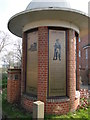
Memorial of Colchester's Goojerat Garrison #2
see also http://www.geograph.org.uk/photo/5281239
Image: © Adrian S Pye
Taken: 13 Feb 2017
0.16 miles
5
Military memorial off Goojerat Road, Colchester
Depicting different eras of conflict and campaigns.
Image: © Jeremy Bolwell
Taken: 22 Jan 2017
0.17 miles
6
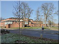
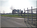
The Garrison Police Station, Colchester
The Colchester base of the Royal Military Police I believe.
Image: © Jeremy Bolwell
Taken: 22 Jan 2017
0.18 miles
7
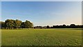
Abbey Field, Colchester
Early evening sunlight on Abbey Field.
Image: © Rebecca A Wills
Taken: 11 Sep 2020
0.21 miles
8
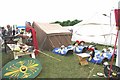
Waddya Mean!!
What have the Romans ever done for you?
A “Roman Officer” telling the public about all those things that the Romans got up to in Britain’s oldest recorded town and Roman capital. Part of the 2009 Colchester Military Festival http://www.gazette-news.co.uk/news/9495706.Military_show_will_rise_from_the_ashes/r/?ref=rss on Abbey Field. The Abbey Field is used as a public open space and is managed by the Garrison.
Image: © Glyn Baker
Taken: 18 Jul 2009
0.24 miles
9
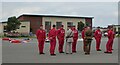
Prince Charles chats with the Red Devils
All safely back on the ground!
Image: © Russel Wills
Taken: 13 Jul 2021
0.25 miles
10
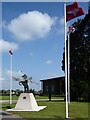
Bellerophon on Pegasus - the official symbol of the Parachute Regiment
Overlooking the parade ground at Merville Barracks, Colchester.
The statue is surrounded by the Parachute Regiment Flag, the Union Flag
and the Pegasus Airborne Flag.
Image: © Russel Wills
Taken: 13 Jul 2021
0.25 miles