IMAGES TAKEN NEAR TO
Hyderabad Close, COLCHESTER, CO2 7FZ
Introduction
This page details the photographs taken nearby to Hyderabad Close, CO2 7FZ by members of the Geograph project.
The Geograph project started in 2005 with the aim of publishing, organising and preserving representative images for every square kilometre of Great Britain, Ireland and the Isle of Man.

There are currently over 7.5m images from over14,400 individuals and you can help contribute to the project by visiting https://www.geograph.org.uk
Image Map
Images are licensed for reuse under creativecommons.org/licenses/by-sa/2.0
Notes
- Clicking on the map will re-center to the selected point.
- The higher the marker number, the further away the image location is from the centre of the postcode.
Image Listing (50 Images Found)
Images are licensed for reuse under creativecommons.org/licenses/by-sa/2.0
Image
Details
Distance
1
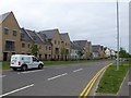
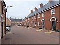
Houses in Roberts Road, Colchester
A 21st century development of housing on the site of the Hyderabad Barracks http://www.camulos.com/militaryheritage/militaryheritage6.htm
Image: © David Smith
Taken: 31 May 2017
0.03 miles
2
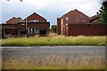
Hyderabad Barracks
These 1950’s barrack blocks are soon to be demolished to make way for “affordable” housing. Some of the nineteenth century buildings will be converted to housing.
Image: © Glyn Baker
Taken: 18 Jul 2009
0.06 miles
3
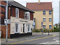
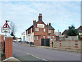
The British Grenadier inn, Colchester
One of several inns with a military name
Image: © David Smith
Taken: 31 May 2017
0.07 miles
4
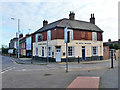
The British Grenadier, Colchester
Across the road from the original site of Colchester garrison to the right, and across another road from the former garrison church to the left.
Image: © Robin Webster
Taken: 17 Jan 2016
0.07 miles
5
The British Grenadier, Colchester
Across the road from the original site of Colchester garrison to the left, and across another road from the former garrison church, glimpsed here beyond the pub.
Image: © Robin Webster
Taken: 17 Jan 2016
0.07 miles
7
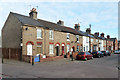
Houses on Winchester Road, Colchester
The road and houses appear on maps in late Victorian times.
Image: © Robin Webster
Taken: 17 Jan 2016
0.08 miles
8
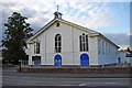
Supreme Irony!
The former Camp (Garrison) Church in Colchester was built as a hospital for soldiers returning from the Crimean War. Rejected by Florence Nightingale it was used for a hundred and fifty years as a place of worship. When Image was taken its future use was uncertain, as the Image were due to move to
Merville Barracks Image . In a twist of fate the building built for a war against the Russians was saved by the Russian Orthodox Church, since 2007 it has been St John’s Orthodox Church http://www.visitcolchester.com/Colchester-St-John's-Orthodox-Church/details/?dms=13&venue=0723030
Image: © Glyn Baker
Taken: 18 Jul 2009
0.09 miles
9
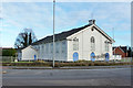
Former Colchester Garrison church
A grade II listed building of 1864, based on huts used in the Crimea War. It is now a Russian Orthodox church.
Image: © Robin Webster
Taken: 17 Jan 2016
0.10 miles
10
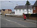
St John's Orthodox Church, Colchester
Formerly the garrison church. On the wall by the pillar box is a WD boundary marker Image]
Image: © David Smith
Taken: 31 May 2017
0.10 miles