IMAGES TAKEN NEAR TO
Chapel Street North, COLCHESTER, CO2 7AT
Introduction
This page details the photographs taken nearby to Chapel Street North, CO2 7AT by members of the Geograph project.
The Geograph project started in 2005 with the aim of publishing, organising and preserving representative images for every square kilometre of Great Britain, Ireland and the Isle of Man.

There are currently over 7.5m images from over14,400 individuals and you can help contribute to the project by visiting https://www.geograph.org.uk
Image Map
Images are licensed for reuse under creativecommons.org/licenses/by-sa/2.0
Notes
- Clicking on the map will re-center to the selected point.
- The higher the marker number, the further away the image location is from the centre of the postcode.
Image Listing (205 Images Found)
Images are licensed for reuse under creativecommons.org/licenses/by-sa/2.0
Image
Details
Distance
1
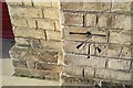
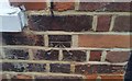
Ordnance Survey 1GL Bolt
This OS cut mark can be found on the east face of the Headgate Theatre. It marks a point 24.9235m above mean sea level.
Image: © Adrian Dust
Taken: 9 Jan 2020
0.01 miles
2
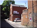
Straws public house, St John's Avenue Colchester
Image: © PAUL FARMER
Taken: 22 May 2010
0.02 miles
3
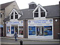
Colchester United Shop, St Isaac's Walk
Image: © PAUL FARMER
Taken: 11 Sep 2010
0.05 miles
4
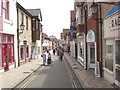
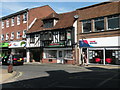
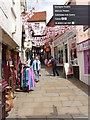
Sir Isaac's Walk, Colchester
This pedestrianised street of small shops is next to modern shopping centres. It runs just inside the Roman wall. There has been a lane here for many centuries.
Image: © David Hawgood
Taken: 15 Jun 2006
0.05 miles
5
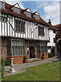
Tymperleys, 15th Century house in Colchester
This timber framed 15th century house is now a clock museum.
Image: © David Hawgood
Taken: 15 Jun 2006
0.05 miles
6
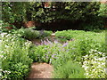
Garden of Tymperleys museum, Colchester
The courtyard and garden of this 15th Century house are a pleasant quiet oasis in the middle of shopping centres.
Image: © David Hawgood
Taken: 15 Jun 2006
0.05 miles
8
Bella Pizza, Crouch Street
Not a listed building
Image: © Keith Edkins
Taken: 6 Aug 2018
0.07 miles
9
Ordnance Survey Cut Mark
This OS cut mark can be found on No8 Sir Isaac Walk. It marks a point 26.509m above mean sea level.
Image: © Adrian Dust
Taken: 7 Jan 2020
0.09 miles
10
Scheregate Steps, Colchester
This is one of the medieval gateways cut through the Roman wall. When the photo was taken it was decorated with flags of St George for England because the Football World Cup was in progress.
Image: © David Hawgood
Taken: 15 Jun 2006
0.09 miles