IMAGES TAKEN NEAR TO
Layer Breton Heath, COLCHESTER, CO2 0PW
Introduction
This page details the photographs taken nearby to Layer Breton Heath, CO2 0PW by members of the Geograph project.
The Geograph project started in 2005 with the aim of publishing, organising and preserving representative images for every square kilometre of Great Britain, Ireland and the Isle of Man.

There are currently over 7.5m images from over14,400 individuals and you can help contribute to the project by visiting https://www.geograph.org.uk
Image Map
Images are licensed for reuse under creativecommons.org/licenses/by-sa/2.0
Notes
- Clicking on the map will re-center to the selected point.
- The higher the marker number, the further away the image location is from the centre of the postcode.
Image Listing (15 Images Found)
Images are licensed for reuse under creativecommons.org/licenses/by-sa/2.0
Image
Details
Distance
1
Cottage, Layer Breton Heath
A grade II listed building, from around 1600.
Image: © Robin Webster
Taken: 28 Nov 2017
0.09 miles
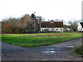
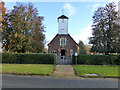
2
St. Mary's church, Layer Breton, Essex
This church was built in 1923.
Image: © Robert Edwards
Taken: 13 Mar 2006
0.10 miles
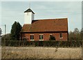
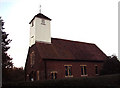
4
Layer Breton church
The Church of St. Mary the Virgin is in a small inclosure of the common land of Layer Breton Heath.
Image: © Robin Webster
Taken: 28 Nov 2017
0.13 miles
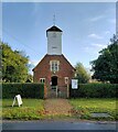
5
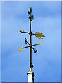
Weather vane, Layer Breton church
For the rest of the church, see Image
Image: © Robin Webster
Taken: 28 Nov 2017
0.13 miles
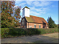
6
Layer Breton church
The Church of St. Mary the Virgin is in a small inclosure of the common land of Layer Breton Heath.
Image: © Robin Webster
Taken: 28 Nov 2017
0.13 miles
7
St Mary the Virgin Church, Layer Bretton, Essex
Image: © Peter Stack
Taken: 22 Nov 2009
0.13 miles
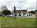
8
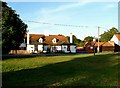
Hare & Hounds at Layer Bretton Heath
This is the Hare & Hounds at Layer Bretton Heath. The piece of green in the foreground is the only bit of ground that remotely resembles a heath now. Over the past 30 years due to lack of grazing and control of grass fires the view from the pub has changed from open grassland and bramble bushes to young broad leaf woodland.
Image: © Glyn Baker
Taken: 9 Oct 2005
0.14 miles
10
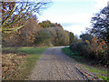
Track, Layer Breton Heath
Leading to a house on the heath remote from the road.
Image: © Robin Webster
Taken: 28 Nov 2017
0.14 miles