IMAGES TAKEN NEAR TO
Olivers Lane, COLCHESTER, CO2 0HJ
Introduction
This page details the photographs taken nearby to Olivers Lane, CO2 0HJ by members of the Geograph project.
The Geograph project started in 2005 with the aim of publishing, organising and preserving representative images for every square kilometre of Great Britain, Ireland and the Isle of Man.

There are currently over 7.5m images from over14,400 individuals and you can help contribute to the project by visiting https://www.geograph.org.uk
Image Map
Images are licensed for reuse under creativecommons.org/licenses/by-sa/2.0
Notes
- Clicking on the map will re-center to the selected point.
- The higher the marker number, the further away the image location is from the centre of the postcode.
Image Listing (3 Images Found)
Images are licensed for reuse under creativecommons.org/licenses/by-sa/2.0
Image
Details
Distance
1
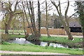
Pond near Olivers
Near the house called Olivers, taken from the path which crosses fields towards the woodland of Oliver's Thicks.
Image: © Trevor Harris
Taken: 18 Apr 2016
0.08 miles
2
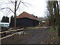
Barn near Olivers
The Barn is located on a footpath that Links Olivers Lane and Layer de la Haye. Olivers is a substantial country house behind the hedge on the right.
Image: © Glyn Baker
Taken: 25 Mar 2006
0.08 miles
3
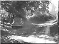
Morris Minor parked in Oliver's lane
I took this pic in black & white to make it appear as an old fashioned photo from the 50s, and not as a modern pic from 2022. The car in question is a Morris Minor MM, which thankfully, has its original reg no (issued in 1952 in East Sussex according to "Where's It From; When was It Issued" book on UK registration numbers I have in my possession); and not one of those "age related" plates you often see on vehicles of its age (which I don't like).
Image: © Mr James D
Taken: 1 Oct 2022
0.21 miles