IMAGES TAKEN NEAR TO
Wethersfield Road, COLCHESTER, CO2 0BB
Introduction
This page details the photographs taken nearby to Wethersfield Road, CO2 0BB by members of the Geograph project.
The Geograph project started in 2005 with the aim of publishing, organising and preserving representative images for every square kilometre of Great Britain, Ireland and the Isle of Man.

There are currently over 7.5m images from over14,400 individuals and you can help contribute to the project by visiting https://www.geograph.org.uk
Image Map
Images are licensed for reuse under creativecommons.org/licenses/by-sa/2.0
Notes
- Clicking on the map will re-center to the selected point.
- The higher the marker number, the further away the image location is from the centre of the postcode.
Image Listing (3 Images Found)
Images are licensed for reuse under creativecommons.org/licenses/by-sa/2.0
Image
Details
Distance
1
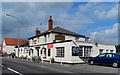
The Cherry Tree pub, Blackheath, Colchester
Image: © Bikeboy
Taken: 13 Sep 2014
0.17 miles
2
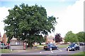
Monkwick Oak (14944)
This Oak survived the building of the Monkwick Estate in Blackheath Colchester during the late 1950's. It is recorded as tree 14944 in the Woodland trusts Ancient Tree Hunt http://www.ancient-tree-hunt.org.uk/
Image: © Glyn Baker
Taken: 2 Aug 2009
0.19 miles
3
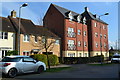
Recently-built housing in William Harris Way
Image: © David Martin
Taken: 28 Mar 2017
0.22 miles