IMAGES TAKEN NEAR TO
Oakmead Road, CLACTON-ON-SEA, CO16 8NW
Introduction
This page details the photographs taken nearby to Oakmead Road, CO16 8NW by members of the Geograph project.
The Geograph project started in 2005 with the aim of publishing, organising and preserving representative images for every square kilometre of Great Britain, Ireland and the Isle of Man.

There are currently over 7.5m images from over14,400 individuals and you can help contribute to the project by visiting https://www.geograph.org.uk
Image Map
Images are licensed for reuse under creativecommons.org/licenses/by-sa/2.0
Notes
- Clicking on the map will re-center to the selected point.
- The higher the marker number, the further away the image location is from the centre of the postcode.
Image Listing (3 Images Found)
Images are licensed for reuse under creativecommons.org/licenses/by-sa/2.0
Image
Details
Distance
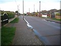
1
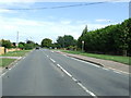
Straight Road
The main road through Point Clear, Essex.
Image: © Keith Evans
Taken: 4 Aug 2009
0.18 miles
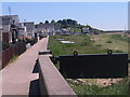
2
Point Clear: Beacon Way
Beacon Way is so named because it leads to Beacon Hill, which is the site of the long since demolished Martello Tower B. However the 1958 large scale Ordnance Survey map shows the road as "Jetty Road".
Image: © Nigel Cox
Taken: 17 Mar 2019
0.19 miles