IMAGES TAKEN NEAR TO
St. Johns Road, CO16 8LQ
Introduction
This page details the photographs taken nearby to St. Johns Road, CO16 8LQ by members of the Geograph project.
The Geograph project started in 2005 with the aim of publishing, organising and preserving representative images for every square kilometre of Great Britain, Ireland and the Isle of Man.

There are currently over 7.5m images from over14,400 individuals and you can help contribute to the project by visiting https://www.geograph.org.uk
Image Map
Images are licensed for reuse under creativecommons.org/licenses/by-sa/2.0
Notes
- Clicking on the map will re-center to the selected point.
- The higher the marker number, the further away the image location is from the centre of the postcode.
Image Listing (5 Images Found)
Images are licensed for reuse under creativecommons.org/licenses/by-sa/2.0
Image
Details
Distance
1

Petrol Station on the B.1027, just east of St. Osyth, Essex
Image: © Robert Edwards
Taken: 4 Oct 2006
0.07 miles
2
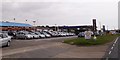
Car sales business and Gulf filling station, St Osyth
Image: © David Smith
Taken: 31 May 2017
0.07 miles
5
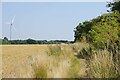
St Osyth Footpath 11
To the left is one of the Image turbines.
Image: © Glyn Baker
Taken: 8 Jul 2023
0.16 miles