IMAGES TAKEN NEAR TO
Colne Way, CLACTON-ON-SEA, CO16 8LL
Introduction
This page details the photographs taken nearby to Colne Way, CO16 8LL by members of the Geograph project.
The Geograph project started in 2005 with the aim of publishing, organising and preserving representative images for every square kilometre of Great Britain, Ireland and the Isle of Man.

There are currently over 7.5m images from over14,400 individuals and you can help contribute to the project by visiting https://www.geograph.org.uk
Image Map
Images are licensed for reuse under creativecommons.org/licenses/by-sa/2.0
Notes
- Clicking on the map will re-center to the selected point.
- The higher the marker number, the further away the image location is from the centre of the postcode.
Image Listing (10 Images Found)
Images are licensed for reuse under creativecommons.org/licenses/by-sa/2.0
Image
Details
Distance

3
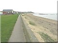
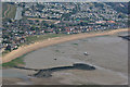
Looking southeast along the Eastern Promenade
Image: © John Baker
Taken: 4 Apr 2014
0.13 miles


10
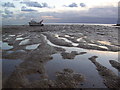
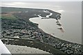
Mud flats at Point Clear Bay
Mud flats in the inter-tidal zone at Point Clear Bay.
Image: © Martin Speck
Taken: 13 Oct 2011
0.24 miles