IMAGES TAKEN NEAR TO
Colchester Road, CLACTON-ON-SEA, CO16 8HS
Introduction
This page details the photographs taken nearby to Colchester Road, CO16 8HS by members of the Geograph project.
The Geograph project started in 2005 with the aim of publishing, organising and preserving representative images for every square kilometre of Great Britain, Ireland and the Isle of Man.

There are currently over 7.5m images from over14,400 individuals and you can help contribute to the project by visiting https://www.geograph.org.uk
Image Map
Images are licensed for reuse under creativecommons.org/licenses/by-sa/2.0
Notes
- Clicking on the map will re-center to the selected point.
- The higher the marker number, the further away the image location is from the centre of the postcode.
Image Listing (11 Images Found)
Images are licensed for reuse under creativecommons.org/licenses/by-sa/2.0
Image
Details
Distance
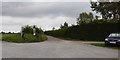
2
Lamb Farm
Lamb Farm is on the B1027 near to the St Osyth turn.
Image: © terry joyce
Taken: 8 Apr 2008
0.04 miles
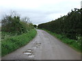
5
Footpath and track to Wellwick Farm
The verge at the junction is being used for selling a car
Image: © David Smith
Taken: 31 May 2017
0.09 miles
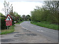
6
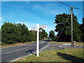
Road junction at St. Osyth
The road straight ahead is a by-pass which avoids the village of St. Osyth. The road to the right leads into the village.
Image: © Malc McDonald
Taken: 18 Jul 2015
0.09 miles
7
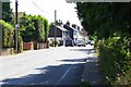
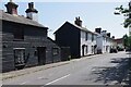
Colchester Rd St Osyth
Looking towards the centre of the village.
Image: © Glyn Baker
Taken: 7 Jul 2023
0.16 miles
8
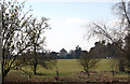
Deer Park, St Osyth
This photo was taken from the northern end of the Deer Park on the main Colchester Road.
If you look carefully, it is possible to see some of the Priory building.
See the Deer. Image
Image: © terry joyce
Taken: 8 Apr 2008
0.17 miles
10
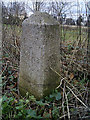
Old Milestone by the former B1027, Colchester Road, St Osyth
Carved stone post by the UC road (was B1027), in parish of ST OSYTH (TENDRING District), Colchester Road, opposite Nos. 76/82, on verge by hedge, on West side of road. Erected by an unknown authority in the 19th century.
Inscription reads:-
: Colchester 11 : : PARISH / OF / ST OSYTH : : Clacton on Sea 5 :
Grade II listed. List Entry Number: 1111479
https://historicengland.org.uk/listing/the-list/list-entry/1111479
Milestone Society National ID: EX_CLCO11.
Image: © JV Nicholls
Taken: 26 Feb 2011
0.21 miles