IMAGES TAKEN NEAR TO
Hunt Drive, CLACTON-ON-SEA, CO16 8EE
Introduction
This page details the photographs taken nearby to Hunt Drive, CO16 8EE by members of the Geograph project.
The Geograph project started in 2005 with the aim of publishing, organising and preserving representative images for every square kilometre of Great Britain, Ireland and the Isle of Man.

There are currently over 7.5m images from over14,400 individuals and you can help contribute to the project by visiting https://www.geograph.org.uk
Image Map
Images are licensed for reuse under creativecommons.org/licenses/by-sa/2.0
Notes
- Clicking on the map will re-center to the selected point.
- The higher the marker number, the further away the image location is from the centre of the postcode.
Image Listing (7 Images Found)
Images are licensed for reuse under creativecommons.org/licenses/by-sa/2.0
Image
Details
Distance
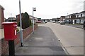
1
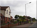
Bus shelter, B1027, east of junction with Constable Avenue
The stop serves a modern estate, several of whose roads are named after artists
Image: © David Smith
Taken: 31 May 2017
0.09 miles
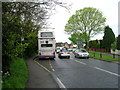
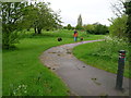
2

The B1027 at Great Clacton
This view shows the direction to St Osyth.
Image: © Robert Edwards
Taken: 10 May 2007
0.16 miles
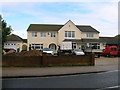
7
Peter Bruff Avenue
A street of typical 1970's vintage houses. I had an idle thought the post box looked rather modern in design, until I noticed the heavy corrosion on one of the seams. Gulp I must be getting old that didn't happen overnight !
Image: © Glyn Baker
Taken: 30 Sep 2023
0.24 miles