IMAGES TAKEN NEAR TO
Bluehouse Avenue, CLACTON-ON-SEA, CO16 7LA
Introduction
This page details the photographs taken nearby to Bluehouse Avenue, CO16 7LA by members of the Geograph project.
The Geograph project started in 2005 with the aim of publishing, organising and preserving representative images for every square kilometre of Great Britain, Ireland and the Isle of Man.

There are currently over 7.5m images from over14,400 individuals and you can help contribute to the project by visiting https://www.geograph.org.uk
Image Map
Images are licensed for reuse under creativecommons.org/licenses/by-sa/2.0
Notes
- Clicking on the map will re-center to the selected point.
- The higher the marker number, the further away the image location is from the centre of the postcode.
Image Listing (6 Images Found)
Images are licensed for reuse under creativecommons.org/licenses/by-sa/2.0
Image
Details
Distance
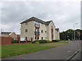
3
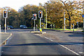
Traffic lights on B1027 St John's Road
For the benefit of those in a fairly new housing development to the left.
Image: © Robin Webster
Taken: 30 Nov 2018
0.22 miles
5
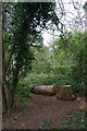
Felled Tree in Coppin's Hall Wood
The local squirrels seemed totally unbothered by my presence until I raised my camera to imortalise them.
Image: © Glyn Baker
Taken: 30 Sep 2023
0.23 miles