IMAGES TAKEN NEAR TO
Landermere, CLACTON-ON-SEA, CO16 0NH
Introduction
This page details the photographs taken nearby to Landermere, CO16 0NH by members of the Geograph project.
The Geograph project started in 2005 with the aim of publishing, organising and preserving representative images for every square kilometre of Great Britain, Ireland and the Isle of Man.

There are currently over 7.5m images from over14,400 individuals and you can help contribute to the project by visiting https://www.geograph.org.uk
Image Map (Loading...)


Getting Data...Please wait
Leaflet Map data © OpenStreetMap
Images are licensed for reuse under creativecommons.org/licenses/by-sa/2.0
Notes
- Clicking on the map will re-center to the selected point.
- The higher the marker number, the further away the image location is from the centre of the postcode.
Image Listing (6 Images Found)
Images are licensed for reuse under creativecommons.org/licenses/by-sa/2.0
Image
Details
Distance
2
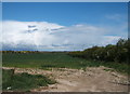
Crop field and hedgerow near New Hall
Looking north from Walton Road.
Image: © JThomas
Taken: 26 Apr 2017
0.04 miles
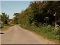
4
Walton Road near New Hall
Looking north west.
Image: © JThomas
Taken: 26 Apr 2017
0.07 miles
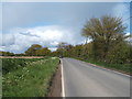
5
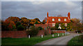
Landermere Hall: view from south, sunset tinted
This fine building (also visible in Image) is a sudden touch of historic class in a relatively bleak landscape, here on the edge of the marshes.
Image: © Zorba the Geek
Taken: 4 Nov 2007
0.15 miles
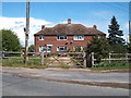
6
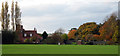
Landermere Hall: view from east, autumn colours
This fine hall stands at the bend of the road that leads to Image and the marshes along Landermere Creek. The front view is visible in Image In the foreground, a recently-drilled crop of winter wheat or barley is growing lushly.
Image: © Zorba the Geek
Taken: 4 Nov 2007
0.17 miles