IMAGES TAKEN NEAR TO
Station Road, CLACTON-ON-SEA, CO16 0HG
Introduction
This page details the photographs taken nearby to Station Road, CO16 0HG by members of the Geograph project.
The Geograph project started in 2005 with the aim of publishing, organising and preserving representative images for every square kilometre of Great Britain, Ireland and the Isle of Man.

There are currently over 7.5m images from over14,400 individuals and you can help contribute to the project by visiting https://www.geograph.org.uk
Image Map
Images are licensed for reuse under creativecommons.org/licenses/by-sa/2.0
Notes
- Clicking on the map will re-center to the selected point.
- The higher the marker number, the further away the image location is from the centre of the postcode.
Image Listing (4 Images Found)
Images are licensed for reuse under creativecommons.org/licenses/by-sa/2.0
Image
Details
Distance
1
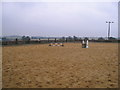
Grange Farm, Thorpe-le-Soken
A horse riding practice ring.
Image: © M J Richardson
Taken: 21 Aug 2007
0.09 miles
2
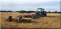
Farm machinery from Grange Farm in a recently ploughed field
Image: © Helen Steed
Taken: 7 Sep 2022
0.12 miles
3
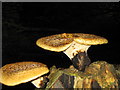
Shaggy Dryad's Saddle
A bracket or polypore fungus, Polyporus squamosus, very common on trunks of dead trees. These were on a stump in a very dark wood just off Station Road, Thorpe-le-Soken.
Image: © M J Richardson
Taken: 24 Aug 2007
0.16 miles
4
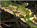
Trametes versicolor - a stump flap fungus
A pale version of this very variable, and very common, 'polypore' or 'bracket' fungus. On a fallen branch in a very dark wood near Thorpe-le-Soken church
Image: © M J Richardson
Taken: 24 Aug 2007
0.18 miles